
Forsinain


Shieling Hut(S) (Post Medieval)
Site Name Forsinain
Classification Shieling Hut(S) (Post Medieval)
Canmore ID 7215
Site Number NC94NW 14
NGR NC 926 475
Datum OSGB36 - NGR
Permalink http://canmore.org.uk/site/7215


- Council Highland
- Parish Farr
- Former Region Highland
- Former District Sutherland
- Former County Sutherland
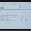
NC94NW 14 926 475.
NC 9254 4754. Square structure 3m by 3m and two courses high, with reed and grass cover.
NC 9262 4756. Rectangular structure with subcircular annexe, 7m by 4m and two courses high.
NC 92269 4757. Rectangular structure, 5m by 3m grass and bracken-cove red.
R J Mercer 1980.
NC 926 475. Six turf-covered shieling footings ranging in size from 9m by 2.5m to 4m by 2m. The structures are rectangular or subrectangular with the larger examples being twin compartmented.
Surveyed at 1:10,000.
Visited by OS 7 November 1980.
Two unroofed shieling-huts are depicted on the 1st edition of the OS 6-inch map (Sutherland 1878, sheet xxxviii). Three unroofed buildings, which may be shieling-huts are shown on the current edition of the OS 1:10,000 map (1962).
Information from RCAHMS (SAH) 24 August 1995

