|
Manuscripts |
MS 823/17 |
|
Correspondence relating to forestry survey report, Glenquicken Moor, Dumfries and Galloway. |
1990 |
Item Level |
|
|
Manuscripts |
MS 823/18 |
|
Monument forms from forestry survey report, Glenquicken Moor, Dumfries and Galloway. |
1990 |
Item Level |
|
|
Prints and Drawings |
DC 17335 |
|
Survey drawings from forestry survey report, Glenquicken Moor, Dumfries and Galloway. |
1990 |
Item Level |
|
|
Manuscripts |
MS 823/19 |
|
Annotated map extracts from forestry survey report, Glenquicken Moor, Dumfries and Galloway. |
1990 |
Item Level |
|
|
Manuscripts |
MS 625/13 |
|
Report on forestry survey, Glenquicken Moor, Dumfries and Galloway. 12 |
1990 |
Item Level |
|
|
Prints and Drawings |
DC 33148 |
|
Annotated plan, based on OS 25-inch map (Kirkcudbright 1894, sheet XL.10-15)
Insc: Creetown, Pibble Mine Site Plan
See DC 33149-153 |
1/1992 |
Item Level |
|
|
Photographs and Off-line Digital Images |
D 87460 PO |
General Collection |
View from NW. |
c. 1965 |
Item Level |
|
|
Manuscripts |
MS 744/184 |
Records of the Royal Commission on the Ancient and Historical Monuments of Scotland (RCAHMS), Edinbu |
Notes compiled from The Story of Ferrytown of Cree and Kirkmabreck Parish by JR Cutland n.d. (1 A4 sheet) by Mr C Girdwood, Dumfries and Galloway Regional Council |
|
Item Level |
|
|
Photographs and Off-line Digital Images |
E 26030 P |
|
Photographic copy of annotated plan, based on OS 25-inch map (Kirkcudbright 1894, sheet XL.10-15)
Insc: Creetown, Pibble Mine Site Plan
See DC 33149-153 |
1/1992 |
Item Level |
|
|
Photographs and Off-line Digital Images |
B 70368 |
|
View of pond from E. |
4/3/1992 |
Item Level |
|
|
Photographs and Off-line Digital Images |
B 70369 |
|
View of pond from S. |
4/3/1992 |
Item Level |
|
|
Photographs and Off-line Digital Images |
B 70370 |
|
View of pond from SW. |
4/3/1992 |
Item Level |
|
|
Photographs and Off-line Digital Images |
B 70371 |
|
Detail of man-made bank of pond. |
4/3/1992 |
Item Level |
|
|
Photographs and Off-line Digital Images |
B 70372 |
|
View of water wheel pit from S. |
4/3/1992 |
Item Level |
|
|
Photographs and Off-line Digital Images |
B 70373 |
|
View of water wheel pit from NW. |
4/3/1992 |
Item Level |
|
|
Photographs and Off-line Digital Images |
B 70374 |
|
View of water wheel pit from NE. |
4/3/1992 |
Item Level |
|
|
Photographs and Off-line Digital Images |
SC 1383433 |
|
Photographic copy of annotated plan, based on OS 25-inch map (Kirkcudbright 1894, sheet XL.10-15)
Insc: Creetown, Pibble Mine Site Plan
See DC 33149-153 |
1/1992 |
Item Level |
|
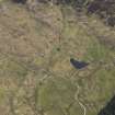 |
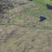
On-line Digital Images |
DP 278085 |
Historic Environment Scotland |
Oblique aerial view. |
16/5/2018 |
Item Level |
|
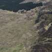 |
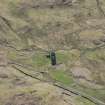
On-line Digital Images |
DP 278086 |
Historic Environment Scotland |
Oblique aerial view. |
16/5/2018 |
Item Level |
|
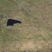 |
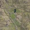
On-line Digital Images |
DP 278087 |
Historic Environment Scotland |
Oblique aerial view. |
16/5/2018 |
Item Level |
|
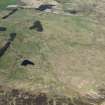 |
On-line Digital Images |
DP 278088 |
Historic Environment Scotland |
Oblique aerial view. |
16/5/2018 |
Item Level |
|
 |
On-line Digital Images |
DP 278089 |
Historic Environment Scotland |
Oblique aerial view. |
16/5/2018 |
Item Level |
|
 |
On-line Digital Images |
DP 278090 |
Historic Environment Scotland |
Oblique aerial view. |
16/5/2018 |
Item Level |
|
 |
On-line Digital Images |
DP 278091 |
Historic Environment Scotland |
Oblique aerial view. |
16/5/2018 |
Item Level |
|


