
Pricing Change
New pricing for orders of material from this site will come into place shortly. Charges for supply of digital images, digitisation on demand, prints and licensing will be altered.
Woodhall House


Country House (Period Unassigned)
Site Name Woodhall House
Classification Country House (Period Unassigned)
Canmore ID 72072
Site Number NS76SE 17
NGR NS 76439 62211
NGR Description Centred on NS 76439 62211
Datum OSGB36 - NGR
Permalink http://canmore.org.uk/site/72072

- Council North Lanarkshire
- Parish Bothwell (Motherwell)
- Former Region Strathclyde
- Former District Motherwell
- Former County Lanarkshire
NS76SE 17 76439 62211.
'Woodhall House' is depicted on OS map (Lanarkshire,). It has since been demolished.
Information from RCAHMS (KD), November 2001.
Woodhall House was built, or possibly rebuilt, by Daniel Campbell of Shawfield sometime between 1711 and 1727. The house was demolished sometime after 1924, and the pavilions more recently. Photographs from c.1900, however, suggest close similarities between the style of the house and the work of the architect, Colin Campbell, who designed Daniel Campbell's Glasgow residence, Shawfield House (also destroyed), between 1707 and 1712. Foundations and other surface remains of Woodhall House and its associated service buildings still survive.
Information from Historic Scotland, August 1992.
A programme of desk study, fieldwalking and trial trenching was carried out in advance of the improvements to the A8 from Baillieston to Newhouse by AOC (Scotland) Ltd. Although some areas of potential archaeological interest were identified in the desk study, fieldwalking and trial trenching did not find any features or areas of archaeological significance. A report will be lodged with the NMRS.
Peter McGowan Associates (Landscape Architects and Urban Designers) also carried out an assessment of the designed landscape around the site of Woodhall House (NS76SE 17; NS 764 621) in association with AOC (Scotland) Ltd. Although the rectilinear layout is derived from the 18th-century formal designed landscape recorded on Roy's Military Survey, very little of the original ornamental or feature planting remains. The area of greatest garden or landscape interest is the walled garden and lake set in woodland to the NW of the house site.
Sponsor: The National Roads Directorate of The Scottish Office Development Department, managed on their behalf by Historic Scotland
AOC (Scotland) Ltd 1996
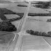
NS 764 621 Peter McGowan Associates (Landscape Architects and Urban Designers) in association with AOC (Scotland) Ltd carried out a designed landscape assessment on Woodhall House, published in November 1995, this was carried out in advance of the proposed land take plan for the upgrading of the present A8 to motorway status. The site of Woodhall House is located around 150m N of the present A8 dual carriageway road, approximately 0.5km S of Calderbank and 3.5km S of Airdrie. The 1st edition OS shows a geometrically planned landscape with an E-W drive/avenue and rectangular field compartments to the S, and a well wooded informal landscape to the N. Roy's Military Survey (c. 1750) shows the rectilinear layout is derived from the 18th century formal designed landscape.
Today the House and its outbuildings have been demolished and no other garden buildings remain. The drive and avenue remains on the E however it is severed by the A8 to the W. The site has been greatly affected by coal mining, which continued over a long period, especially in the NW half of the polocies. The site is also affected by the two associated railways.
All the woodland belts and groups remain both to the N and S and are the dominant component of the landscape to the N. In the post war period practically all the woodland has been felled and replanted, often with a coniferous component or the trees have been coppiced. It seems very little ornamental or feature planting remains. The area of greatest garden or landscape interest is the area of the walled garden and lakewhich is set in woodland to the NW of the house site.
The main value of the site today is for the legacy of extensive policy woodland belts situated within a green undeveloped pocket ringed by Coatbridge-Airdrie-Newhouse-Holytown-Mossend-Bellshill-Uddingston and so on. The report argues this gives character to the landscape as well as screening the urban areas from the road.
The report concludes that the value of the designed landscape is severly reduced by the loss of all buildings, the state of neglect of landscape features and the extensive effects of mining and sub division by railways and the A8. The site has a few remaining areas of interest, the lake and walled garden are highlighted, but overall the site has detriorated too far to be of value for preservation as an entire designed landscape. It is suggested that the lake and walled garden are worth preserving and restoring for possible future uses as county park or parkland. The policy woodland areas and belts are still important today and are significant in relation to the road proposals. Their retention and relationship to the proposed landform and planting of the motorway corridor should be considered in the road proposals. The motorway proposals overall seem to mainly affect the less well preserved parts of the landscape to the S of the present A8. Loss of the Dovecote Plantation should perhaps be compensated for in the motorway landscape proposals.
Sponsor: Historic Scotland
NMRS MS/830/8 November 1995
EXTERNAL REFERENCE
UNIVERSITY OF GLASGOW ARCHIVES
D 101/12/2 Note of settlement of Price of the Woodhall Estate prepared by Alexander Whitelaw Esq from the Woodhall Estate Company #145,000 - January 1874.
Bundle 12/3 Repairs Mansion House 3rd July 1899. Wright work of Roof at Woodhall House on the Estate of Woodhall.
10 August 1899 Measurements of the Slater and Plumber work at Woodhall House for Alexander Whitelaw by Adam Pringle.
D 101/12/2 Envelope of photographs addressed to Alexander Thomson, Architect, Airdrie
D 101/D2 Portico
Kitchen Wing
Mansion House
Report on condition of house 1924 as the result of universal workings.
A map of Woodhall Seat of Daniel Campbell of Shawfield Esq. Surveyed in the year 1735 by ( ) McDougall.
D 101/D9 Woodhall Estate. Menerial Damages. Draft memorandum by James Thomson & Sons Airdrie. During September 1904 Alexander H. Thomson took sizes and sketch detail drawings of the following buildings at Woodhall: East Stable wing, West Stable wing, Business premises.

