
Torwood - Raeburnfoot - Newstead


Roman Road (Roman)
Site Name Torwood - Raeburnfoot - Newstead
Classification Roman Road (Roman)
Canmore ID 71988
Site Number NY29NE 56
NGR NY 250 990
NGR Description NY 250 990 to NY 2590 9999
Datum OSGB36 - NGR
Permalink http://canmore.org.uk/site/71988


- Council Dumfries And Galloway
- Parish Eskdalemuir
- Former Region Dumfries And Galloway
- Former District Annandale And Eskdale
- Former County Dumfries-shire
NY29NE 56 250 990 to 2590 9999 RR 3.
Formerly RR 89
See also NT20SE 24, NT30SW 3, NY18NW 31, NY18NE 11, NY18SW 80, NY19SE 26, NY29NW 17 and NY29SW 49.
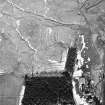
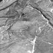
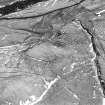
'For two miles north-east of the Roman fort at Raeburnfoot (NY29NE 5, centred NY 2510 9908) the valley of the Rae Burn offers no convincing remains of ancient roadways. ... A modern cart-track wanders tortuously up the north side of the valley, and only close to the ford and bluff between Kiln Sike (NY 2548 9943) and White Sike (NT 2605 0038) is there any suggestion of a more solid road.'
I A Richmond.
No trace of Roman road in cultivated ground between the Roman fort at Raeburnfoot and sheet edge to W. Course uncertain.
NY 250 990 - NY 2590 9999 No trace; modern track on line.
Visited by OS (IA) October 1973.
For most of the length between Raeburnfoot and Craik Cross, this Roman road has been left as a cutting in a forestry plantation, and its details are, in consequence obscured by long grass.
Visited by RCAHMS (RJCM, SPH, PC), August 1980.
Field Visit (August 1980)
Roman Road, Craik Cross Hill to Raeburnfoot
The Roman road linking Lauderdale with Eskdale enters the area of survey at Craik Cross Hill (NT 303 047); from this point to Raeburnfoot fort (NY29NE 5) it is remarkable for the scale of its engineering, which involved lengthy cuttings and terraces, and the use of the natural rock (laid bare by removal of the overlying peat and brash) as the road-surface.
RCAHMS 1980, visited August 1980
(Richmond 1946; Margary 1973, 461-4, no. 89)
Note (1997)
NY 250 993 – 2590 9999 NY29NE 56
Listed as part of Ladyward - Raeburnfoot - Craik Cross Roman road. See also NT20SE 24, NT30SW 3, NY18NW 31, NY18NE 11, NY18SW 80, NY19SE 26, NY29NW 17 and NY29SW 49.
RCAHMS 1997.

