
Torwood - Raeburnfoot - Newstead


Roman Road (Roman)
Site Name Torwood - Raeburnfoot - Newstead
Classification Roman Road (Roman)
Canmore ID 71987
Site Number NY29NW 17
NGR NY 2249 9500
NGR Description NY 2249 9500 to NY 2480 9838
Datum OSGB36 - NGR
Permalink http://canmore.org.uk/site/71987


- Council Dumfries And Galloway
- Parish Eskdalemuir
- Former Region Dumfries And Galloway
- Former District Annandale And Eskdale
- Former County Dumfries-shire
NY29NW 17 2249 9500 to 2480 9838 RR 3.
Formerly RR 89
See also NT20SE 24, NT30SW 3, NY18NW 31, NY18NE 11, NY18SW 80, NY19SE 26, NY29NE 56 and NY29SW 49.
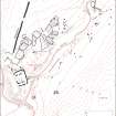
The Roman road probably followed the line of the Lockerbie - Eskdalemuir road (B723) from sheet edge as far as the foot of Letterstone Bank (NY 2290 9544) from which point there is no definite trace until at the watershed just E of Watcarrick Dinnings, where 'a transverse ridge has been cut through by a notch probably of some 50 yards; and although the eastermost 20 yards of this notch probably represent no more than a hollowed traffic-track, the westernmost portion must have been cut out purposefully, and is doubtless Roman work' (Graham 1950, 232, Plate XLIV, 2). No further remains can be identified with certainty for some 100 yds, though what seems to be an artificial bay on the E side of the small moss, with a scarp up to 5 ft in height, may well indicate its course. For a further 250 yds, the course has been washed out by a small burn; then there is a stretch of terraced roadway some 120 yds long and up to 27 ft broad, which reaches a wall at NY 2444 9786, from which point to NY 2480 9838, there are traffic-tracks of post-Roman age. The line of the road between Fauld Brae (NY 232 959) and Craik Knowes (NY 239 972) is scheduled.
A Graham 1950; I D Margary 1973; RCAHMS 1980.
NY 2249 9500 - NY 2290 9544 No trace of Roman road; modern road probably on line.
NY 2290 9544 - NY 2322 9595 No trace in forest.
NY 2322 9595 - NY 2328 9635 Roman line appears as a grassy strip through newly planted forest. Several non-Roman quarry pits.
NY 2328 9635 - NY 2335 9645 Terrace 6m wide.
NY 2335 9645 - NY 2366 9696 Grassy strip through newly planted forest. No Roman characteristics.
NY 2366 9696 - NY 2386 9710 Course follows broad natural mound through forest.
NY 2386 9740 - NY 2395 9723 Slight hollow way through trees.
NY 2395 9723 - NY 2405 9724 Cutting, as described by Graham.
NY 2405 9724 - NY 2435 9772 Course mutilated by a series of small burns and land drains.
NY 2435 9772 - NY 2444 9786 Poorly preserved terrace.
Visited by OS (BS) May 1975.
NY 2444 9786 - NY 2480 9838 No trace.
NY 2480 9838 - sheet edge No trace in cultivated fields. Course uncertain.
Visited by OS (IA) October 1973.
Field Visit (August 1980)
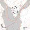
Roman Road, Sandyford to Raeburnfoot
The Roman road from Annandale to Raeburnfoot fort (NY29NE 5) probably entered the area of survey at NY 200 934 and followed the line of the Lockerbie-Eskdalemuir road (B 723) as far as the foot of Letterstone Shank (NY 229 954) from which point there is no definite trace until it appears as a cutting E of Watcarrick Dinnings (NY 238 971 ). The line of the road between Fauld Brae (NY 232 959) and Craik Knowes (NY 239 972) has been afforded statutory protection.
RCAHMS 1980, visited August 1980
(Graham 1948; Margary 1973, 462, no. 89)
Note (1997)
NY 2249 9500 – 2480 NY29NW 17
Listed as part of Ladyward - Raeburnfoot - Craik Cross Roman road. See also NT20SE 24, NT30SW 3, NY18NW 31, NY18NE 11, NY18SW 80, NY19SE 26, NY29NE 56 and NY29SW 49.
RCAHMS 1997.

