 |
On-line Digital Images |
DP 080121 |
RCAHMS Aerial Photography Digital |
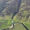
General oblique aerial view of the remains of the township buildings, rig, field systems and hut-circles, taken from the SSW. |
29/5/2009 |
Item Level |
|
 |
On-line Digital Images |
DP 080122 |
RCAHMS Aerial Photography Digital |
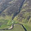
General oblique aerial view of the remains of the township buildings, rig, field systems and hut-circles, taken from the SSW. |
29/5/2009 |
Item Level |
|
 |
On-line Digital Images |
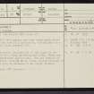
SC 2350823 |
Records of the Ordnance Survey, Southampton, Hampshire, England |
Halgarry, NC92SW 3, Ordnance Survey index card, page number 1, Recto |
1958 |
Item Level |
|


