
Halgarry


Hut Circle (Prehistoric)
Site Name Halgarry
Classification Hut Circle (Prehistoric)
Canmore ID 7188
Site Number NC92SW 3
NGR NC 9207 2019
Datum OSGB36 - NGR
Permalink http://canmore.org.uk/site/7188


- Council Highland
- Parish Kildonan
- Former Region Highland
- Former District Sutherland
- Former County Sutherland
NC92SW 3 9207 2019.
(NC 9207 2019) Hut Circle (NR) (site of)
OS 6"map, (1963)
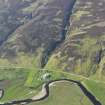
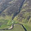
East of the Allt Halligarry, and some sixty yards above the road, is the site of a hut-circle, visible only as a platform about 12.0m diameter.
RCAHMS 1911, visited 1909; Visited by OS (W D J) 3 June 1961
This is a hut-circle levelled out of the slope in the bottom reaches of a steep SW-facing hillside. There are no signs of associated agriculture. The hut remains as a platform, about 13.0m NW-SE by 10.5m, having vestiges of a wall on the rim; an entrance is no longer evident.
Revised at 1/10,000.
Visited by OS (J M) 7 December 1976

