
Following the launch of trove.scot in February 2025 we are now planning the retiral of some of our webservices. Canmore will be switched off on 24th June 2025. Information about the closure can be found on the HES website: Retiral of HES web services | Historic Environment Scotland
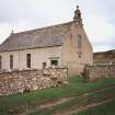
Kildonan, Church Of Scotland Parish Church


Burial Ground (Period Unknown), Church (18th Century)
Site Name Kildonan, Church Of Scotland Parish Church
Classification Burial Ground (Period Unknown), Church (18th Century)
Alternative Name(s) St Donnan's Church
Canmore ID 7175
Site Number NC92SW 18
NGR NC 90993 20739
Datum OSGB36 - NGR
Permalink http://canmore.org.uk/site/7175


- Council Highland
- Parish Kildonan
- Former Region Highland
- Former District Sutherland
- Former County Sutherland
NC92SW 18 90993 20739.
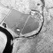
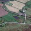
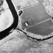
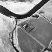
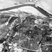
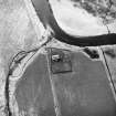
(NC 9099 2073) St Donnan's Church, the church of Kildonan parish to which it gives name, dates from about 1786, but stands on the site of its Early Christian and medieval predecessors.
Name, dedication and tradition are all that remain of the original church, founded by St Donnan who died in 617. A large hollow stone, known as Donnan's Chair or Seat, stood half-way between Kildonan and Helmsdale (NC91NW 21). His fair was held at Kildonan until the 17th century.
The medieval church consisted, in the middle of the 13th century of nave and chancel with a small mortuary chapel of the Clan Gunn at the west end. This church was demolished when the present church was built, some of the material being incorporated in the latter.
Origines parochiales Scotiae (OPS) 1855; A B Scott 1906; D Sage 1889; Statistical Account (OSA) 1794; W J Watson 1926;
The church is still in use.
Visited by OS (W D J) 2 June 1961
Within the older half of the present graveyard are distinct traces of an earlier irregularly-shaped enclosure, having church in NE corner. It is visible on the north and west as a well-defined raised ledge about 1ft high and on the east and SE as a slope, quite pronounced in the SE corner. The south side is lost under a modern wall and the SW corner is vague with what appears to be a subsidiary ridge running off to the south. A raised area at the east end of the church suggests earlier occupation. The formerly cross-marked boulder (NC92SW 22) is said to have been a sanctuary cross of this church and the carved "Abbot's Head" (NC92SW 19), Tigh-an-Abb (NC92SW 23) and the cross-marked 'Clach n h-Uaighe' (NC92SW 1) also presumably have some connection with the church.
A D S Macdonald and L R Laing 1973
The environs of the church bear the traces of the enclosure planned by MacDonald & Laing, but the noted raised area should read at West, nor East, end of church. The church is still in use.
Visited by OS (J M) 8 Feburary 1977
ARCHITECT: James Boag 1788
Note (28 May 2025)
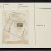
A church and cemetery are depicted on the 1st edition of the OS 6-inch map (Sutherland 1879, sheet LXXVIII). The cemetery was expanded and is depicted on the OS 1:10,560 map (1963).
information from HES 28 May 2025

