
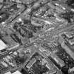
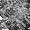
Musselburgh, High Street, General


General View (Period Unassigned)
Site Name Musselburgh, High Street, General
Classification General View (Period Unassigned)
Canmore ID 71746
Site Number NT37SW 548
NGR NT 3450 7250
NGR Description From NT 34252 72607 to NT 34833 72816
Datum OSGB36 - NGR
Permalink http://canmore.org.uk/site/71746


- Council East Lothian
- Parish Inveresk (East Lothian)
- Former Region Lothian
- Former District East Lothian
- Former County Midlothian

