
Following the launch of trove.scot in February 2025 we are now planning the retiral of some of our webservices. Canmore will be switched off on 24th June 2025. Information about the closure can be found on the HES website: Retiral of HES web services | Historic Environment Scotland
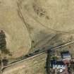
Border - Crawford - Inveresk (?)


Roman Road (Roman)
Site Name Border - Crawford - Inveresk (?)
Classification Roman Road (Roman)
Canmore ID 71721
Site Number NT25NW 33
NGR NT 2000 5993
NGR Description NT 2000 5993 to NT 2005 5999
Datum OSGB36 - NGR
Permalink http://canmore.org.uk/site/71721

- Council Midlothian
- Parish Penicuik (Midlothian)
- Former Region Lothian
- Former District Midlothian
- Former County Midlothian

