
Following the launch of trove.scot in February 2025 we are now planning the retiral of some of our webservices. Canmore will be switched off on 24th June 2025. Information about the closure can be found on the HES website: Retiral of HES web services | Historic Environment Scotland
Border - Crawford - Inveresk (?)


Roman Road (Roman)
Site Name Border - Crawford - Inveresk (?)
Classification Roman Road (Roman)
Alternative Name(s) West Linton
Canmore ID 71716
Site Number NT15SW 34
NGR NT 1263 5000
NGR Description NT 1263 5000 to NT 1499 5444
Datum OSGB36 - NGR
Permalink http://canmore.org.uk/site/71716


- Council Scottish Borders, The
- Parish Linton (Tweeddale)
- Former Region Borders
- Former District Tweeddale
- Former County Peebles-shire
NT15SW 34 1263 5000 to 1499 5444 RR 1.
Formerly RR 7g.
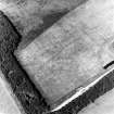
NT15SW 34.01 NT 145 535 Roman road; trial excavation
NT15SW 34.02 NT 1465 5384 Roman road; quarry pits
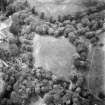
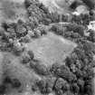
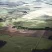
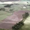
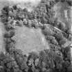
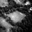
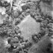
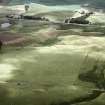
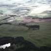
There are no certain traces of the Roman road from sheet edge (NT 1263 5000) as far as the crossing of the Lyne Water. The remains noted by St Joseph, followed by Margary in the plantation at NT 126 500, and on the E side of Hardgatehead (NT 129 504) are simply hollow-ways. It is therefore reasonable to assume that the road continued in the straight line noted on as far as the plantation (NT 1263 5001) and its course from there to Medwyn House (NT 142 522) coincides with that of the 18th-century turnpike. St Joseph considers that the road passed imnediately W of Medwyn House and, N of Lyne Water, to the E of Lynedale House. A cutting confirming the existence of an old route along this line occurs on the S bank some 100 yds down-stream from the present bridge. RCAHMS note that no signs of the Roman road can be seen at the crossing of the Lyne Water, and between Lynedale and Siller Holes it has been obliterated by later roads. It reappears in the plantation on Cock Rig (NT 146 537) and can be traced from there beyond sheet edge either as a terrace or a low mound, running through cultivated fields.
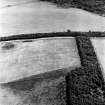
In the spring of 1959, when the ground had been newly ploughed, a number of large stones, torn from the foundations of the road, could be seen on the surface at NT 1494 5434 together with patches of metalling.
J K St Joseph 1952; I D Margary 1957; RCAHMS 1967.
NT 1263 5000 - NT 1356 5135 Old road/path probably on course of Roman road (WDJ)
NT 1356 5135 - NT 1416 5219 No trace. Old track probably on line for most of the way. (WDJ)
NT 1416 5219 - NT 1419 5244 Road descends to crossing over the Lyne Water by a terraced way. (WDJ)
NT 1419 5244 - NT 1421 5258 No trace. (WDJ)
NT 1421 5258 - NT 1453 5348 Modern road probably on line. (WDJ)
NT 1453 5348 - NT 1462 5372 No trace. (WDJ)
NT 1462 5372 - NT 1462 5375 Slight hollow in wood. (WDJ)
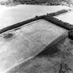
NT 1462 5375 - NT 1495 5436 Causeway plain; occasional quarry pits. (JLD)
NT 1495 5436 - NT 1499 5444 Shelf c. 4m broad with mound 4-5m broad on E side; possible agger in ploughed field. (JLD)
Visited by OS (JLD) 1959; (WDJ) 1970.
Sbc Note
Visibility: This is an upstanding earthwork or monument.
Information from Scottish Borders Council

