
Skye, Ard Beg


Enclosure (Period Unknown)
Site Name Skye, Ard Beg
Classification Enclosure (Period Unknown)
Canmore ID 71438
Site Number NG26SW 8
NGR NG 2196 6112
Datum OSGB36 - NGR
Permalink http://canmore.org.uk/site/71438

- Council Highland
- Parish Duirinish
- Former Region Highland
- Former District Skye And Lochalsh
- Former County Inverness-shire
Field Visit (29 October 1990)
NG26SW 8 2196 6112.
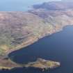
An arc of bank cuts off a small promontary to the E of Ard Beg enclosing an area some 80m from E to W by no more than 70m transversely.
(WAT90 1135)
Visited by RCAHMS (DCC) 29 October 1990.
Note (21 January 2015 - 18 May 2016)
This relatively low-lying promontory has been enclosed by a bank drawn across its landward side on the S and along its E margin above the rocky foreshore. Irregular on plan, the interior measures about 47m from N to S by 44m transversely (0.13ha). It tails off into a broad rocky foreshore at its seaward end. While evidently some kind of promontory enclosure, it is unlikely to be the remains of a fortification as such.
Information from An Atlas of Hillforts of Great Britain and Ireland – 18 May 2016. Atlas of Hillforts SC2732

