
Skye, Trumpan Mor


Township (Post Medieval)
Site Name Skye, Trumpan Mor
Classification Township (Post Medieval)
Alternative Name(s) Lag Nan Tighean
Canmore ID 71416
Site Number NG26SW 5.02
NGR NG 2365 6021
NGR Description NG 2365 6021 to NG 2327 6085
Datum OSGB36 - NGR
Permalink http://canmore.org.uk/site/71416


- Council Highland
- Parish Duirinish
- Former Region Highland
- Former District Skye And Lochalsh
- Former County Inverness-shire
Field Visit (28 September 1990)
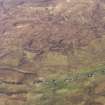
NG26SW 5.02 2365 6021 to 2327 6085.
There are at least eighteen buildings and five enclosures strung out along a shallow valley partially occupied by Halistra Loch, an artificial lake, created after the second edition of the Ordnance Survey map of 1904 (Island of Skye &c., Inverness-shire, 1904, ix). They appear to fall into nine units of at least one and up to four buildings, generally with a conjoined enclosure. Two buildings (WAT90 124-135) have evidence of phasing. All the buildings and enclosures are shown as unroofed on the first and second editions of the Ordnance Survey maps (Island of Skye, Inverness-shire, 1880, 1904, ix).
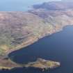
To the N (NG 233 609) is a further cluster of at least seventeen buildings and two enclosures on both sides of an unnamed burn on the W side of the public road. Most are shown as unroofed on the first and second editions of the Ordnance Survey maps. The area to the N has been heavily improved.
(WAT90 109-138, 189-212).
Visited by RCAHMS (DCC) 28 September 1990.

