
Following the launch of trove.scot in February 2025 we are now planning the retiral of some of our webservices. Canmore will be switched off on 24th June 2025. Information about the closure can be found on the HES website: Retiral of HES web services | Historic Environment Scotland
Kirkstile Knowe


Burnt Mound (Prehistoric)
Site Name Kirkstile Knowe
Classification Burnt Mound (Prehistoric)
Alternative Name(s) Ryecastle Burn; Broomhillbank Hill
Canmore ID 71260
Site Number NY19SW 28
NGR NY 12741 90394
Datum OSGB36 - NGR
Permalink http://canmore.org.uk/site/71260


- Council Dumfries And Galloway
- Parish Applegarth
- Former Region Dumfries And Galloway
- Former District Annandale And Eskdale
- Former County Dumfries-shire
Measured Survey (14 August 1990)
RCAHMS surveyed the burnt mound at Kirkstile Knowe on 14 August 1990 with plane-table and alidade, producing a plan at a scale of 1:125.
Field Visit (18 July 1990)
NY19SW 28 12741 90394
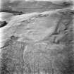
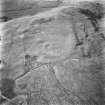
This burnt mound lies in a damp hollow on the S flank of Kirkstile Knowe, immediately to the E of a branch of the Ryecastle Burn. Roughly circular on plan, it measures 9.7m from NW to SE by 9.1m transversely and stands to a height of 1.4m. A hollow, opening to the NE, measures 4.7m from NE to SW by 4.3m transversely. The nature of the mound was tested by the removal of a turf revealing a mass of reddened angular fragments of stone and small pieces of charcoal within a matrix of loose black earth.
Visited by RCAHMS (SMF) 18 July 1990.
Listed as burnt mound.
RCAHMS 1997.

