
Pricing Change
New pricing for orders of material from this site will come into place shortly. Charges for supply of digital images, digitisation on demand, prints and licensing will be altered.
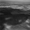
Gold Knowe


Enclosure (Period Unassigned)(Possible)
Site Name Gold Knowe
Classification Enclosure (Period Unassigned)(Possible)
Canmore ID 70824
Site Number NT57NE 75
NGR NT 58034 75060
Datum OSGB36 - NGR
Permalink http://canmore.org.uk/site/70824


- Council East Lothian
- Parish Prestonkirk
- Former Region Lothian
- Former District East Lothian
- Former County East Lothian
Aerial Photographic Transcription (17 June 1991)
An aerial transcription was produced from oblique aerial photographs. Information from Historic Environment Scotland (BM) 31 March 2017.
Aerial Photographic Interpretation (3 March 2005)
NT57NE 75 58034 75060.
An arc of what may be the ditch of a roughly circular enclosure has been recorded as cropmarks on oblique aerial photographs (RCAHMSAP 1989), lying on the terrace at the foot of the N flank of Traprain Law. The enclosure may measure about 40m in diameter.
Information from RCAHMS (DCC) 3 March 2005

