
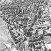
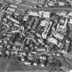
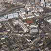
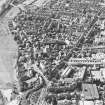
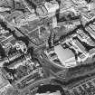
Dundee, Perth Road, General


General View (Period Unassigned)
Site Name Dundee, Perth Road, General
Classification General View (Period Unassigned)
Canmore ID 70471
Site Number NO32NE 398
NGR NO 37750 29828
NGR Description From NO 36446 29992 to NO 39806 29833
Datum OSGB36 - NGR
Permalink http://canmore.org.uk/site/70471


- Council Dundee, City Of
- Parish Dundee (Dundee, City Of)
- Former Region Tayside
- Former District City Of Dundee
- Former County Angus
NO32NE 398 37750 29828
Perth Road continues from mapsheet NO32NE onto mapsheet NO33SE.
NMRS REFERENCE
Perth Road, Villa
Architect: C & L Ower
Perth Road, Villas
Architect: J. Murray Robertson
Perth Road, Villa for Lawson
Architect: Patrick Thoms & Wilkie

