|
Prints and Drawings |
DC 32264 |
Records of the Royal Commission on the Ancient and Historical Monuments of Scotland (RCAHMS), Edinbu |
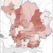
Map showing the distribution of medieval parish churches (named) in Annandale and Eskdale, against the pattern of parish boundaries at the present day. Published in Eastern Dumfriesshire: an archaeological landscape. |
1996 |
Item Level |
|
|
Photographs and Off-line Digital Images |
SC 381346 |
Papers of Professor John R Hume, economic and industrial historian, Glasgow, Scotland |
Photograph of church at Hutton and Corrie. |
|
Item Level |
|
 |
On-line Digital Images |
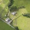
DP 107772 |
RCAHMS Aerial Photography Digital |
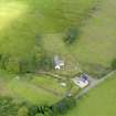
Oblique aerial view of Hutton and Corrie Parish Church, taken from the ENE. |
3/8/2011 |
Item Level |
|
 |
On-line Digital Images |
DP 107773 |
RCAHMS Aerial Photography Digital |
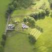
Oblique aerial view of Hutton and Corrie Parish Church, taken from the NW. |
3/8/2011 |
Item Level |
|
 |
On-line Digital Images |
DP 107774 |
RCAHMS Aerial Photography Digital |
Oblique aerial view of Hutton and Corrie Parish Church, taken from the W. |
3/8/2011 |
Item Level |
|
 |
On-line Digital Images |
DP 107775 |
RCAHMS Aerial Photography Digital |
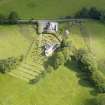
Oblique aerial view of Hutton and Corrie Parish Church, taken from the SW. |
3/8/2011 |
Item Level |
|
 |
On-line Digital Images |
DP 107776 |
RCAHMS Aerial Photography Digital |
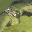
Oblique aerial view of Hutton and Corrie Parish Church, taken from the N. |
3/8/2011 |
Item Level |
|
 |
On-line Digital Images |
SC 1917793 |
Records of the Royal Commission on the Ancient and Historical Monuments of Scotland (RCAHMS), Edinbu |
Map showing the distribution of medieval parish churches (named) in Annandale and Eskdale, against the pattern of parish boundaries at the present day. Published in Eastern Dumfriesshire: an archaeological landscape. |
1996 |
Item Level |
|
|
Digital Files (Non-image) |
GV 007469 |
Records of the Royal Commission on the Ancient and Historical Monuments of Scotland (RCAHMS), Edinbu |
Map showing the distribution of medieval parish churches (named) in Annandale and Eskdale, against the pattern of parish boundaries at the present day. Published in Eastern Dumfriesshire: an archaeological landscape. |
1996 |
Item Level |
|


