Accessibility

Font Size

100% 150% 200%

Background Colour

Default Contrast
Close Reset

Edinburgh, Raf Turnhouse Airfield

Airfield (20th Century), Building(S) (20th Century), Commemorative Monument (20th Century), War Memorial (20th Century)

Site Name Edinburgh, Raf Turnhouse Airfield

Classification Airfield (20th Century), Building(S) (20th Century), Commemorative Monument (20th Century), War Memorial (20th Century)

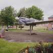
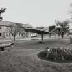
Alternative Name(s) Turnhouse Aerodrome; Turnhouse Airport; Battle Of Britain War Memorial

Canmore ID 70030

Site Number NT17SE 70

NGR NT 1581 7362

NGR Description Centred NT 1581 7362

Datum OSGB36 - NGR

Permalink http://canmore.org.uk/site/70030

Ordnance Survey licence number AC0000807262. All rights reserved.
Canmore Disclaimer. © Bluesky International Limited 2025. Public Sector Viewing Terms

Toggle Aerial | View on large map

Digital Images

General oblique aerial view of Carlowrie Country House with the runway in the foreground and the Bridges in the distance, looking N.
General oblique aerial view of Carlowrie Country House with the runway in the foreground and the Bridges in the distance, looking N.Joint Maritime Operational Training Staff building, view from North East.APFS, administration, PSA offices, view from South West.Military transport supply hangar, detail of East front.Fields workshop and store, view from South East.Headquarters of 24 Group Royal Observer Corps offices, view from South East.Supplyfit Education Section, and library buildings, view from South East.Water tower, view from South.Old sports store, view from South East.Gymnasium, from South East.Armoury, view from South West.Prefabricated building (behind Headquarters of the Air Training Corps building), view from SouthSignage, detail.Oblique aerial view of the runway at the airport while coming in to land, taken from the SW.Oblique aerial view of the new control tower, looking NNE.Oblique aerial view.Main guardroom, view from North East.Main guardroom and station headquarters, view from West.MTSS accommodation store, view from South West.View of building 20.Military transport supply hangar, detail of door mechanism.Headquarters of 24 Group Royal Observer Corps offices, view from North West.Station headquarters, view from West.Fields hangar, view from North West.Officer's mess, view from East.Control tower, view from East.Air raid shelter, view from West.Oblique aerial view of the runway at the airport while coming in to land, taken from the SW.Oblique aerial view looking along the runway at Edinburgh airport on approach for landing, taken from the WSW.Oblique aerial view.Oblique aerial view.Oblique aerial view.Aerial view.Aerial view.View from South EastJoint Maritime Operational Training Staff building, view from North West.Main guardroom and station headquarters, view from West.Military transport garage and sub station, view from South West.AEF cinema and locker room, view from South.Military transport supply hangar, view from South.Military transport supply hangar, detail of doors.Water tower, view from South.Main gate and station headquarters, view from North.Main gate, view from North East.Station headquarters, view from West.Fields hangar, view from South East.Fields hangar, detail of door gantry.Fields hangar, interior detail of roof.Fields hangar, detail of bottom of door.Royal Observor Corps bunker, view from South East.Officer's mess, view from South.View of ELUAS Decontam building.CIO store, view from North East.Officer's mess annexe, view from South West.Spitfire memorial, view from South East.Oblique aerial view.Oblique aerial view.Inflam.store, view from South West.Military transport and military transport coach garage, view from South West.Military transport supply hangar, detail of East front.Supplyfit Education Section and library buildings, view from South West.Static water tank, view from South.Main gate and station headquarters, view from North.Fields hangar, view from South West.Royal Observor Corps bunker, view from South.Royal Observor Corps bunker, view from South.Campbell housing block and Cruickshank housing block, view from South.Catering offices and store, view from South.Signage, detail.Station headquarters, hall, detail of clocking-in machineControl tower, view from North WestGeneral oblique aerial view of the Royal Bank of Scotland building with the Bridges in the distance, looking N.Oblique aerial view.Sub station and MTSS accommodation store, view from East.Station headquarters, hall, detail of trophy cabinet.Fields hangar, view from South West.Fields hangar, view from South East.Fields hangar, interior view from West.Officer's mess, detail of East entrance door.Cruickshank housing block, view from North East.Officer's mess annexe, view from North East.Spitfire memorial, view from South West.Scanned image of Luftwaffe vertical air photograph of Turnhouse Airfield, Edinburgh and surrounding area.Oblique aerial view.Oblique aerial view centred on the SE-NW runway, taken from the NW.General oblique aerial view of Carlowrie Country House with the runway in the foreground, looking NNE.Main guardroom, view from North East.Military transport supply hangar, view from South.Main gate, view from North East.Fields hangar, detail of bottom of door.Fields hangar, detail of sign on door.Officer's mess, view from South.Officer's mess, view from EastCampbell housing block, view from South East.Housing, view from South East.Housing, view from South East.Control tower, view from East.Oblique aerial view centred on the former RAF base at Turnhouse, taken from the WNW.Joint Maritime Operational Training Staff building, view from North West.Main guardroom, view from South East.

First 100 images shown. See the Collections panel (below) for a link to all digital images.

Administrative Areas

  • Council Edinburgh, City Of
  • Parish Edinburgh (Edinburgh, City Of)
  • Former Region Lothian
  • Former District City Of Edinburgh
  • Former County Midlothian

Archaeology Notes

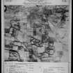
NT17SE 70.00 Centred 1581 7362

For Edinburgh Airport see NT17SE 69 and for Turnhouse Airport Terminal Building (Matthew, 1954) see NT17SE 346.

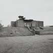
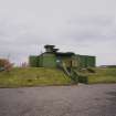
NT17SE 70.01 NT 1606 7432 Pillbox

NT17SE 70.02 NT 1713 7420 Pillbox

NT17SE 70.03 NT 1709 7395 Pillbox

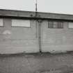
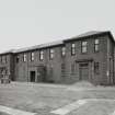
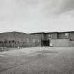
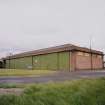
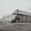
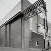
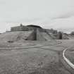
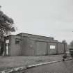
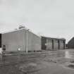
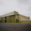
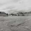
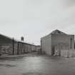
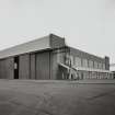
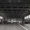
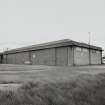
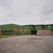
NT17SE 70.04 NT 1410 7390 Aircraft Hangar

NT17SE 70.05 NT 1630 7395 Aircraft Hangar

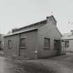
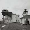
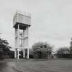
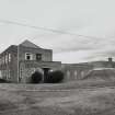
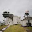
NT17SE 70.06 NT 1592 7400 Operations Block

NT17SE 70.07 NT 1595 7431 Pillbox

NT17SE 70.08 NT 1556 7409 Pillbox

NT17SE 70.09 NT 15753 73145 Pillbox

NT17SE 70.10 NT 1588 7395 Pillbox

NT17SE 70.11 NT 1559 7388 Pillbox

NT17SE 70.12 NT 1569 7417 Pillbox

NT17SE 70.13 NT 1536 7305 Pillbox (possible)

NT17SE 70.14 NT 1605 7383 Pillbox

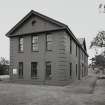
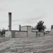
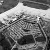
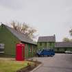
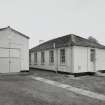
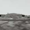
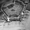
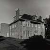
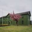
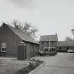
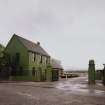
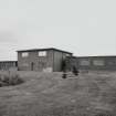
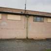
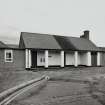
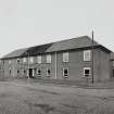
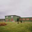
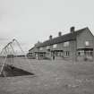
NT17SE 70.15 NT 1600 7418 Buildings; Houses (Domestic site); Gas Decontamination Centre

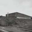
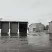
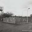
NT17SE 70.16 NT 15836 73204 Dispersal Bay

NT17SE 70.17 centred NT 15831 73944 Buildings (new freight terminal)

NT17SE 70.18 NT 15900 73800 Airfield (First World War)

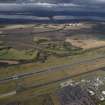
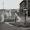
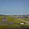
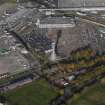
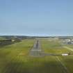
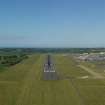
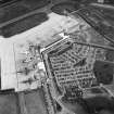
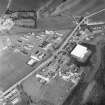
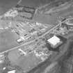
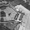
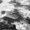
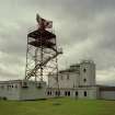
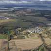
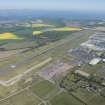
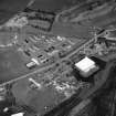
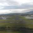
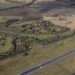
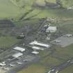
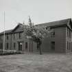
This airfield was used during WWI, opening in 1916, but reduced in status during 1917. At the start of WWII it became a sector Station and during late 1939 concrete runways were built. The airfield was temporarily closed during 1961 for reconstruction to the main runway and control tower. When British Airports Authority took over in 1971 it was decided to construct a totally new runway to the NW along with a new terminal building (see NT17SE 69).

D J Smith 1983

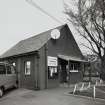
Part of RAF Turnhouse is used by Edinburgh Airport (NT17SE 69) and the RAF base has closed during 1997. The original terminal building has been demolished.

J A Guy 1997; NMRS MS 810/5, 65-9

Architecture Notes

Turnhouse Aerodrome (see NT17SE 70.18)

ARCHITECT: Charles Campbell

(work done at aerodrome during 1914-18 war)

Activities

Project (February 2014 - July 2014)

A data upgrade project to record war memorials.

References

MyCanmore Image Contributions


Contribute an Image

MyCanmore Text Contributions