
Kilphedir


Field System (Period Unassigned), Hut Circle(S) (Prehistoric)
Site Name Kilphedir
Classification Field System (Period Unassigned), Hut Circle(S) (Prehistoric)
Alternative Name(s) Allt Cille Pheadair
Canmore ID 6998
Site Number NC91NE 25
NGR NC 990 193
Datum OSGB36 - NGR
Permalink http://canmore.org.uk/site/6998
Ordnance Survey licence number AC0000807262. All rights reserved.
Canmore Disclaimer.
© Bluesky International Limited 2025. Public Sector Viewing Terms
- Correction
- Favourite


DP 207941
Excavation drawing : plan of heathery hut circle.
Papers of Dr Horace Fairhurst, archaeologist, Glasgow, Scotland
1962
© Courtesy of HES (Papers of Dr Horace Fairhurst, archaeologist, Glasgow, Scotland)

DP 208013
Graph of Kilphedir control profile no.3 - values expressed as % of total tree pollen.
Papers of Dr Horace Fairhurst, archaeologist, Glasgow, Scotland
1963
© Courtesy of HES (Papers of Dr Horace Fairhurst, archaeologist, Glasgow, Scotland)


SC 1874931
General of stone remains.
Papers of Dr Horace Fairhurst, archaeologist, Glasgow, Scotland
1963
© Courtesy of HES (Papers of Dr Horace Fairhurst, archaeologist, Glasgow, Scotland)

SC 1874933
Pottery base with steatite grits from Hut Circle I.
Papers of Dr Horace Fairhurst, archaeologist, Glasgow, Scotland
1963
© Courtesy of HES (Papers of Dr Horace Fairhurst, archaeologist, Glasgow, Scotland)

SC 1874941
Excavation photograph.
Papers of Dr Horace Fairhurst, archaeologist, Glasgow, Scotland
1963
© Courtesy of HES (Papers of Dr Horace Fairhurst, archaeologist, Glasgow, Scotland)

SC 1874956
General view of area.
Papers of Dr Horace Fairhurst, archaeologist, Glasgow, Scotland
1963
© Courtesy of HES (Papers of Dr Horace Fairhurst, archaeologist, Glasgow, Scotland)

SC 1874966
Excavation photograph.
Papers of Dr Horace Fairhurst, archaeologist, Glasgow, Scotland
1963
© Courtesy of HES (Papers of Dr Horace Fairhurst, archaeologist, Glasgow, Scotland)

SC 1874973
Excavation photograph.
Papers of Dr Horace Fairhurst, archaeologist, Glasgow, Scotland
1963
© Courtesy of HES (Papers of Dr Horace Fairhurst, archaeologist, Glasgow, Scotland)

SC 1874978
Excavation photograph : Kilphedir glen with tent marking location of hut circles and arable land.
Papers of Dr Horace Fairhurst, archaeologist, Glasgow, Scotland
1963
© Courtesy of HES (Papers of Dr Horace Fairhurst, archaeologist, Glasgow, Scotland)

SC 1874992
Excavation photograph : Hut Circle I - west sector (hearth in baulk) section.
Papers of Dr Horace Fairhurst, archaeologist, Glasgow, Scotland
1963
© Courtesy of HES (Papers of Dr Horace Fairhurst, archaeologist, Glasgow, Scotland)

SC 1875003
Excavation photograph : excavation Hut Circle I showing depth of peat cover.
Papers of Dr Horace Fairhurst, archaeologist, Glasgow, Scotland
1963
© Courtesy of HES (Papers of Dr Horace Fairhurst, archaeologist, Glasgow, Scotland)

SC 1875005
Excavation photograph.
Papers of Dr Horace Fairhurst, archaeologist, Glasgow, Scotland
1963
© Courtesy of HES (Papers of Dr Horace Fairhurst, archaeologist, Glasgow, Scotland)


SC 726752
Excavation photograph : excavation of Hut Circle III.
Papers of Dr Horace Fairhurst, archaeologist, Glasgow, Scotland
1963
© Courtesy of HES (Papers of Dr Horace Fairhurst, archaeologist, Glasgow, Scotland)

DP 207935
Excavation drawing : plan of hut circle V, Kilpheder.
Papers of Dr Horace Fairhurst, archaeologist, Glasgow, Scotland
c. 1963
© Courtesy of HES (Papers of Dr Horace Fairhurst, archaeologist, Glasgow, Scotland)

SC 1874927
General view of area.
Papers of Dr Horace Fairhurst, archaeologist, Glasgow, Scotland
1963
© Courtesy of HES (Papers of Dr Horace Fairhurst, archaeologist, Glasgow, Scotland)

SC 1874932
General view of area.
Papers of Dr Horace Fairhurst, archaeologist, Glasgow, Scotland
1963
© Courtesy of HES (Papers of Dr Horace Fairhurst, archaeologist, Glasgow, Scotland)

SC 1874938
Excavation photograph : quadrant in hut circle III.
Papers of Dr Horace Fairhurst, archaeologist, Glasgow, Scotland
1963
© Courtesy of HES (Papers of Dr Horace Fairhurst, archaeologist, Glasgow, Scotland)

SC 1874943
Excavation photograph.
Papers of Dr Horace Fairhurst, archaeologist, Glasgow, Scotland
1963
© Courtesy of HES (Papers of Dr Horace Fairhurst, archaeologist, Glasgow, Scotland)

SC 1874949
General view of area.
Papers of Dr Horace Fairhurst, archaeologist, Glasgow, Scotland
1963
© Courtesy of HES (Papers of Dr Horace Fairhurst, archaeologist, Glasgow, Scotland)

SC 1874957
Excavation photograph : Hut Circle I - east wall.
Papers of Dr Horace Fairhurst, archaeologist, Glasgow, Scotland
1963
© Courtesy of HES (Papers of Dr Horace Fairhurst, archaeologist, Glasgow, Scotland)

SC 1874964
Excavation photograph.
Papers of Dr Horace Fairhurst, archaeologist, Glasgow, Scotland
1963
© Courtesy of HES (Papers of Dr Horace Fairhurst, archaeologist, Glasgow, Scotland)

SC 1874965
Excavation photograph.
Papers of Dr Horace Fairhurst, archaeologist, Glasgow, Scotland
1963
© Courtesy of HES (Papers of Dr Horace Fairhurst, archaeologist, Glasgow, Scotland)

SC 1874975
Excavation photograph : general view of arable ground.
Papers of Dr Horace Fairhurst, archaeologist, Glasgow, Scotland
1963
© Courtesy of HES (Papers of Dr Horace Fairhurst, archaeologist, Glasgow, Scotland)

SC 1874979
Excavation photograph : Kilphedir glen with tent marking location of hut circles and arable land.
Papers of Dr Horace Fairhurst, archaeologist, Glasgow, Scotland
1963
© Courtesy of HES (Papers of Dr Horace Fairhurst, archaeologist, Glasgow, Scotland)

SC 1874986
Excavation photograph : later Y-shaped walling in Hut Circle V.
Papers of Dr Horace Fairhurst, archaeologist, Glasgow, Scotland
1963
© Courtesy of HES (Papers of Dr Horace Fairhurst, archaeologist, Glasgow, Scotland)

SC 1874989
Excavation photograph : Hut Circle I - section across wall - soil stripped.
Papers of Dr Horace Fairhurst, archaeologist, Glasgow, Scotland
1963
© Courtesy of HES (Papers of Dr Horace Fairhurst, archaeologist, Glasgow, Scotland)

SC 1874990
Excavation photograph : Hut Circle I - NW sector and post holes.
Papers of Dr Horace Fairhurst, archaeologist, Glasgow, Scotland
1963
© Courtesy of HES (Papers of Dr Horace Fairhurst, archaeologist, Glasgow, Scotland)

SC 1874991
Excavation photograph : Hut Circle I - section across wall - soil stripped.
Papers of Dr Horace Fairhurst, archaeologist, Glasgow, Scotland
1963
© Courtesy of HES (Papers of Dr Horace Fairhurst, archaeologist, Glasgow, Scotland)

SC 1875002
Excavation photograph : excavation Hut Circle I showing depth of peat cover.
Papers of Dr Horace Fairhurst, archaeologist, Glasgow, Scotland
1963
© Courtesy of HES (Papers of Dr Horace Fairhurst, archaeologist, Glasgow, Scotland)


SC 1875022
Excavation photograph.
Papers of Dr Horace Fairhurst, archaeologist, Glasgow, Scotland
1963
© Courtesy of HES (Papers of Dr Horace Fairhurst, archaeologist, Glasgow, Scotland)

SC 1875026
Excavation photograph : excavation of Hut Circle III.
Papers of Dr Horace Fairhurst, archaeologist, Glasgow, Scotland
1963
© Courtesy of HES (Papers of Dr Horace Fairhurst, archaeologist, Glasgow, Scotland)

SC 2350538
Kilphedir, NC91NE 25, Ordnance Survey index card, page number 3, Recto
Records of the Ordnance Survey, Southampton, Hampshire, England
c. 1958
© Crown Copyright: HES (Ordnance Survey Archaeology Division)

SC 2350539
Kilphedir, NC91NE 25, Ordnance Survey index card, page number 1, Recto
Records of the Ordnance Survey, Southampton, Hampshire, England
c. 1958
© Crown Copyright: HES (Ordnance Survey Archaeology Division)

SC 2667797
Excavation photograph : excavation of Hut Circle III.
Papers of Dr Horace Fairhurst, archaeologist, Glasgow, Scotland
1963
© Courtesy of HES (Papers of Dr Horace Fairhurst, archaeologist, Glasgow, Scotland)


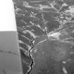
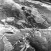
SC 1009590
Oblique aerial view of the hut-circles and field systems and the Allt Cille Pheadair, looking to the N.
Records of Aberdeen Aerial Surveys, Aberdeen, Scotland
18/3/1985
© Copyright: Ian Ralston. Courtesy of HES.

DP 207939
Excavation drawing : sections of hut circle V.
Papers of Dr Horace Fairhurst, archaeologist, Glasgow, Scotland
© Courtesy of HES (Papers of Dr Horace Fairhurst, archaeologist, Glasgow, Scotland)

DP 207947
Excavation drawing : plans of chambered cairns.
Papers of Dr Horace Fairhurst, archaeologist, Glasgow, Scotland
© Courtesy of HES (Papers of Dr Horace Fairhurst, archaeologist, Glasgow, Scotland)

DP 207957
Excavation drawing : plan of iron age settlement at Kilphedir showing excavated areas and clearance cairns. (see PSAS 103 65-99 fig 2)
Papers of Dr Horace Fairhurst, archaeologist, Glasgow, Scotland
© Courtesy of HES (Papers of Dr Horace Fairhurst, archaeologist, Glasgow, Scotland)


SC 1874940
Excavation photograph.
Papers of Dr Horace Fairhurst, archaeologist, Glasgow, Scotland
1963
© Courtesy of HES (Papers of Dr Horace Fairhurst, archaeologist, Glasgow, Scotland)

SC 1874947
Excavation photograph : Hut Circle I.
Papers of Dr Horace Fairhurst, archaeologist, Glasgow, Scotland
1963
© Courtesy of HES (Papers of Dr Horace Fairhurst, archaeologist, Glasgow, Scotland)

SC 1874951
General view of area.
Papers of Dr Horace Fairhurst, archaeologist, Glasgow, Scotland
1963
© Courtesy of HES (Papers of Dr Horace Fairhurst, archaeologist, Glasgow, Scotland)

SC 1874952
General view of area.
Papers of Dr Horace Fairhurst, archaeologist, Glasgow, Scotland
1963
© Courtesy of HES (Papers of Dr Horace Fairhurst, archaeologist, Glasgow, Scotland)

SC 1874955
General view of area.
Papers of Dr Horace Fairhurst, archaeologist, Glasgow, Scotland
1963
© Courtesy of HES (Papers of Dr Horace Fairhurst, archaeologist, Glasgow, Scotland)

SC 1874958
Excavation photograph.
Papers of Dr Horace Fairhurst, archaeologist, Glasgow, Scotland
1963
© Courtesy of HES (Papers of Dr Horace Fairhurst, archaeologist, Glasgow, Scotland)

SC 1874961
Excavation photograph : Hut Circle I - SW sector before wall was sectioned.
Papers of Dr Horace Fairhurst, archaeologist, Glasgow, Scotland
1963
© Courtesy of HES (Papers of Dr Horace Fairhurst, archaeologist, Glasgow, Scotland)

SC 1874962
Excavation photograph : Hut Circle I - NE sector, wall with post holes.
Papers of Dr Horace Fairhurst, archaeologist, Glasgow, Scotland
1963
© Courtesy of HES (Papers of Dr Horace Fairhurst, archaeologist, Glasgow, Scotland)

SC 1874967
Excavation photograph.
Papers of Dr Horace Fairhurst, archaeologist, Glasgow, Scotland
1963
© Courtesy of HES (Papers of Dr Horace Fairhurst, archaeologist, Glasgow, Scotland)

SC 1874968
Excavation photograph.
Papers of Dr Horace Fairhurst, archaeologist, Glasgow, Scotland
1963
© Courtesy of HES (Papers of Dr Horace Fairhurst, archaeologist, Glasgow, Scotland)

SC 1874980
General view of area.
Papers of Dr Horace Fairhurst, archaeologist, Glasgow, Scotland
1963
© Courtesy of HES (Papers of Dr Horace Fairhurst, archaeologist, Glasgow, Scotland)

SC 1874995
Excavation photograph : extended entrance to Hut Circle V.
Papers of Dr Horace Fairhurst, archaeologist, Glasgow, Scotland
1963
© Courtesy of HES (Papers of Dr Horace Fairhurst, archaeologist, Glasgow, Scotland)

SC 1874999
Excavation photograph : hut circle.
Papers of Dr Horace Fairhurst, archaeologist, Glasgow, Scotland
1963
© Courtesy of HES (Papers of Dr Horace Fairhurst, archaeologist, Glasgow, Scotland)


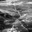
SC 1896333
An oblique aerial view of the Allt Cille Pheadair, Kilphedir, Strath of Kildonan, East Sutherland, looking WNW.
Papers of James Sloan Bone, landscape historian, Inverness, Highland, Scotland
1998
© Copyright: NOSAS (James S Bone Collection). Courtesy of HES.

SC 2350535
Kilphedir, NC91NE 25, Ordnance Survey index card, page number 1, Recto
Records of the Ordnance Survey, Southampton, Hampshire, England
c. 1958
© Crown Copyright: HES (Ordnance Survey Archaeology Division)

SC 2350536
Kilphedir, NC91NE 25, Ordnance Survey index card, page number 2, Verso
Records of the Ordnance Survey, Southampton, Hampshire, England
c. 1958
© Crown Copyright: HES (Ordnance Survey Archaeology Division)

DP 207945
Excavation drawing : plan of hut circle I. (see publication drawing in PSAS 103, 65-99, fig 3)
Papers of Dr Horace Fairhurst, archaeologist, Glasgow, Scotland
© Courtesy of HES (Papers of Dr Horace Fairhurst, archaeologist, Glasgow, Scotland)

DP 207946
Excavation drawing : plans of chambered cairns.
Papers of Dr Horace Fairhurst, archaeologist, Glasgow, Scotland
© Courtesy of HES (Papers of Dr Horace Fairhurst, archaeologist, Glasgow, Scotland)

DP 207948
Excavation drawing : plan of hut circle I.
Papers of Dr Horace Fairhurst, archaeologist, Glasgow, Scotland
© Courtesy of HES (Papers of Dr Horace Fairhurst, archaeologist, Glasgow, Scotland)

DP 207951
Excavation drawing : section W-E through hut circle III
Papers of Dr Horace Fairhurst, archaeologist, Glasgow, Scotland
© Courtesy of HES (Papers of Dr Horace Fairhurst, archaeologist, Glasgow, Scotland)

DP 208009
Publication drawing : Kilphedir the pottery. (see PSAS 103, 65-99, fig 7)
Papers of Dr Horace Fairhurst, archaeologist, Glasgow, Scotland
© Courtesy of HES (Papers of Dr Horace Fairhurst, archaeologist, Glasgow, Scotland)

DP 208011
Graph of Kilphedir profile no.2 - values expressed as % of total tree pollen.
Papers of Dr Horace Fairhurst, archaeologist, Glasgow, Scotland
© Courtesy of HES (Papers of Dr Horace Fairhurst, archaeologist, Glasgow, Scotland)

SC 1874946
Excavation photograph : Hut Circle I.
Papers of Dr Horace Fairhurst, archaeologist, Glasgow, Scotland
1963
© Courtesy of HES (Papers of Dr Horace Fairhurst, archaeologist, Glasgow, Scotland)

SC 1874953
General view of area.
Papers of Dr Horace Fairhurst, archaeologist, Glasgow, Scotland
1963
© Courtesy of HES (Papers of Dr Horace Fairhurst, archaeologist, Glasgow, Scotland)

SC 1874972
Excavation photograph : excavation of Hut Circle I showing depth of peat cover.
Papers of Dr Horace Fairhurst, archaeologist, Glasgow, Scotland
1963
© Courtesy of HES (Papers of Dr Horace Fairhurst, archaeologist, Glasgow, Scotland)

SC 1874981
General view of area.
Papers of Dr Horace Fairhurst, archaeologist, Glasgow, Scotland
1963
© Courtesy of HES (Papers of Dr Horace Fairhurst, archaeologist, Glasgow, Scotland)

SC 1874983
Excavation photograph : small hut circle - view of section.
Papers of Dr Horace Fairhurst, archaeologist, Glasgow, Scotland
1963
© Courtesy of HES (Papers of Dr Horace Fairhurst, archaeologist, Glasgow, Scotland)

SC 1874985
Excavation photograph : later Y-shaped walling in Hut Circle V.
Papers of Dr Horace Fairhurst, archaeologist, Glasgow, Scotland
1963
© Courtesy of HES (Papers of Dr Horace Fairhurst, archaeologist, Glasgow, Scotland)

SC 1874987
Excavation photograph : extended entrance to Hut Circle V.
Papers of Dr Horace Fairhurst, archaeologist, Glasgow, Scotland
1963
© Courtesy of HES (Papers of Dr Horace Fairhurst, archaeologist, Glasgow, Scotland)

SC 1874993
Excavation photograph.
Papers of Dr Horace Fairhurst, archaeologist, Glasgow, Scotland
1963
© Courtesy of HES (Papers of Dr Horace Fairhurst, archaeologist, Glasgow, Scotland)

SC 1874994
Excavation photograph : extended entrance to Hut Circle V.
Papers of Dr Horace Fairhurst, archaeologist, Glasgow, Scotland
1963
© Courtesy of HES (Papers of Dr Horace Fairhurst, archaeologist, Glasgow, Scotland)

SC 1875004
Excavation photograph : cutting across Bronze Age field dyke.
Papers of Dr Horace Fairhurst, archaeologist, Glasgow, Scotland
1963
© Courtesy of HES (Papers of Dr Horace Fairhurst, archaeologist, Glasgow, Scotland)

SC 1875007
Excavation photograph : Hut Circle I - west wall before sectioned.
Papers of Dr Horace Fairhurst, archaeologist, Glasgow, Scotland
1963
© Courtesy of HES (Papers of Dr Horace Fairhurst, archaeologist, Glasgow, Scotland)

SC 1875009
Excavation photograph.
Papers of Dr Horace Fairhurst, archaeologist, Glasgow, Scotland
1963
© Courtesy of HES (Papers of Dr Horace Fairhurst, archaeologist, Glasgow, Scotland)


SC 1875023
Excavation photograph : extended entrance of Hut Circle V.
Papers of Dr Horace Fairhurst, archaeologist, Glasgow, Scotland
1963
© Courtesy of HES (Papers of Dr Horace Fairhurst, archaeologist, Glasgow, Scotland)

SC 1875024
Excavation photograph.
Papers of Dr Horace Fairhurst, archaeologist, Glasgow, Scotland
1963
© Courtesy of HES (Papers of Dr Horace Fairhurst, archaeologist, Glasgow, Scotland)

DP 207938
Excavation drawing : section AB, hut circle I.
Papers of Dr Horace Fairhurst, archaeologist, Glasgow, Scotland
© Courtesy of HES (Papers of Dr Horace Fairhurst, archaeologist, Glasgow, Scotland)

DP 207942
Excavation drawing : plan of stony hut circle, Kilphedir.
Papers of Dr Horace Fairhurst, archaeologist, Glasgow, Scotland
© Courtesy of HES (Papers of Dr Horace Fairhurst, archaeologist, Glasgow, Scotland)

DP 207955
Excavation drawing : section across east face of cutting through hut circle V.
Papers of Dr Horace Fairhurst, archaeologist, Glasgow, Scotland
1964
© Courtesy of HES (Papers of Dr Horace Fairhurst, archaeologist, Glasgow, Scotland)

DP 208012
Graph of Kilphedir profile no.1 - values expressed as % of total tree pollen.
Papers of Dr Horace Fairhurst, archaeologist, Glasgow, Scotland
© Courtesy of HES (Papers of Dr Horace Fairhurst, archaeologist, Glasgow, Scotland)
![Publication drawing; plan of 'Hut Circle [A], Allt Cille Pheadair'.](http://i.rcahms.gov.uk/canmore/l/SC01665103.jpg)
SC 1665103
Publication drawing; plan of 'Hut Circle [A], Allt Cille Pheadair'.
Records of the Royal Commission on the Ancient and Historical Monuments of Scotland (RCAHMS), Edinbu
c. 1909
© Crown Copyright: HES


SC 1874928
General view of area.
Papers of Dr Horace Fairhurst, archaeologist, Glasgow, Scotland
1963
© Courtesy of HES (Papers of Dr Horace Fairhurst, archaeologist, Glasgow, Scotland)

SC 1874936
Excavation photograph : excavation of Hut Circle III.
Papers of Dr Horace Fairhurst, archaeologist, Glasgow, Scotland
1963
© Courtesy of HES (Papers of Dr Horace Fairhurst, archaeologist, Glasgow, Scotland)

SC 1874939
Excavation photograph.
Papers of Dr Horace Fairhurst, archaeologist, Glasgow, Scotland
1963
© Courtesy of HES (Papers of Dr Horace Fairhurst, archaeologist, Glasgow, Scotland)

SC 1874944
Excavation photograph.
Papers of Dr Horace Fairhurst, archaeologist, Glasgow, Scotland
1963
© Courtesy of HES (Papers of Dr Horace Fairhurst, archaeologist, Glasgow, Scotland)

SC 1874948
Excavation photograph : Hut Circle II.
Papers of Dr Horace Fairhurst, archaeologist, Glasgow, Scotland
1963
© Courtesy of HES (Papers of Dr Horace Fairhurst, archaeologist, Glasgow, Scotland)

SC 1874984
Excavation photograph : saddle quern.
Papers of Dr Horace Fairhurst, archaeologist, Glasgow, Scotland
1963
© Courtesy of HES (Papers of Dr Horace Fairhurst, archaeologist, Glasgow, Scotland)

SC 1874988
Excavation entrance to Hut Circle V.
Papers of Dr Horace Fairhurst, archaeologist, Glasgow, Scotland
1963
© Courtesy of HES (Papers of Dr Horace Fairhurst, archaeologist, Glasgow, Scotland)


SC 726740
Excavation photograph : later Y-shaped walling in Hut Circle V.
Papers of Dr Horace Fairhurst, archaeologist, Glasgow, Scotland
1963
© Courtesy of HES (Papers of Dr Horace Fairhurst, archaeologist, Glasgow, Scotland)

DP 207936
Excavation drawing : plan of hut circle III, Kilpheder.
Papers of Dr Horace Fairhurst, archaeologist, Glasgow, Scotland
c. 1963
© Courtesy of HES (Papers of Dr Horace Fairhurst, archaeologist, Glasgow, Scotland)


![Publication drawing; plan of 'Hut Circle [A], Allt Cille Pheadair'.](http://i.rcahms.gov.uk/canmore/s/SC01665103.jpg)


First 100 images shown. See the Collections panel (below) for a link to all digital images.
- Council Highland
- Parish Kildonan
- Former Region Highland
- Former District Sutherland
- Former County Sutherland
NC91NE 25 990 193
See also NC91NE 3.
(NC 990 194) (5) Enclosures (NR)
(Undated) annotation on OS map.
A settlement of five hut circles (I-V) excavated by Fairhurst between 1963 and 1968. Two types of huts were distinguished, type I and type II. The first occupation of the site was about 500 BC.
RCAHMS 1911; H Fairhurst 1971; H Fairhurst and D B Taylor 1974.
Each of the four type I huts consisted of a low perimeter wall in which had rested the ends of the rafters of a conical roof supported on a ring of posts half way between the wall and the hut centre. There was no evidence of central posts. In, or near, the centre of each was a hearth. Internal diameters were between 20ft and 40ft. Coarse, generally flat rimmed, pottery was found. Hut V, the only type II hut, was found to incorporate the remnants of one of the earlier type I huts, and was dated to c. 130BC. It had a higher, thicker wall, lined on the inside with slabs, which expanded at the entrance to form a passage 5.0m long. Finds included potsherds of a smoother harder ware, one with an everted rim, a saddle quern, and pounders and rubbing stones.
Contemporary agriculture is evidenced by clearance heaps, and stony banks edging plots. Fairhurst (1971) implies that the clearance cairns were possibly contemporary with the type I huts, and the stony banks with the type II house, suggesting a change in cultivation methods.
E W MacKie 1969; Visited by OS (W D J) 20 May 1960.
This is a settlement of five huts (I-V) in association with a field system as described by Fairhurst.
Re-surveyed at 1:10,560.
Visited by OS (W D J) 20 October 1976.

