
North Uist, Hougharry


Smithy (Period Unassigned), Township (Period Unassigned)
Site Name North Uist, Hougharry
Classification Smithy (Period Unassigned), Township (Period Unassigned)
Canmore ID 69646
Site Number NF77SW 29
NGR NF 7049 7110
Datum OSGB36 - NGR
Permalink http://canmore.org.uk/site/69646


- Council Western Isles
- Parish North Uist
- Former Region Western Isles Islands Area
- Former District Western Isles
- Former County Inverness-shire
Field Visit (1 June 2012)
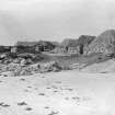
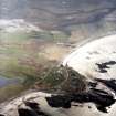
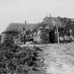
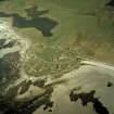
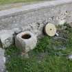
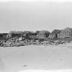
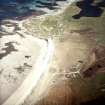
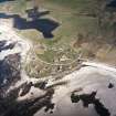
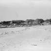
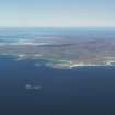
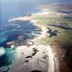
Hougary township occupies a low machair headland between Traigh nam Faoghailean to the S and Traigh Bhan to the N. On plan, the township is triangular, with buildings ranged along the coast on the N and SW and inland on the E, and its fullest extent is probably best represented on the 1st and 2nd editions of the OS 25-inch map (Inverness-shire, Hebrides (North Uist) 1881 and 1903, Sheet XXXIII.7). None of the buildings that remain occupied were noted on the date of visit: fourteen ruined ones were.
NF 70479 71221: This rectangular building is situated above the rocky shoreline on the NW side of the township. It measures 10m from NE to SW by 5.5m transversely over roughly coursed rubble walls that still stands to wall-head. There is a central entrance on the SE.
NF 70496 71208: This building has been reduced to a rectangular platform measuring about 15m from NNE to SSW by 5.5m transversely and up to 1m high. Its NNE end is overlain by a small, crudely-built, grass-grown subrectangular enclosure which has also been filled-in with rubble.
NF 70473 71185: This rectangular building measures about 9m from N to S by 3m transversely over roughly coursed rubble walls standing to a wall-head which is partly capped with concrete blocks. There is a central entrance on the E.
NF 70463 71176: This rectangular building, which is situated on the cliff above the rocky shoreline on the NW side of the township, has been re-roofed and converted into a shed. It measures about 10m from WNW to ESE by 4.5m transversely over course rubble walls,
NF 70472 71133: This rectangular building is situated in a garden above the rocky shoreline on the W side of the township. It measures about 12m from NE to SW by 6m transversely and its low walls have been capped with turf.
NF 70562 71025: This rectangular building, which lies towards the southern end of the township, measures about 15m from NNE to SSW by 6m transversely over heavily robbed grass-grown rubble walls. Its NNE end has been terraced into the rising ground below the public road.
NF 70541 71047: This rectangular building measures 9m from NE to SW by 4.5m transversely over roughly coursed rubble masonry but its entire SE side has been removed and what is left of the building is now used as a car park.
NF 70547 71036: This rectangular building measures about 15m from NE to SW transversely over low, grass-grown, roughly coursed rubble walls.
NF 70594 71104: This rectangular building, which stands immediately N of a modern house, measures about 9m from NW to SE by 5.5m transversely over roughly coursed rubble walls. Although it lacks a roof, the SE gable (containing a small widow) still survives.
NF 70622 71109: This rectangular building has been largely reduced to its foundations except at its WNW end where part of it still stands to wall-head height. The building measures about 9m from ESE to WNW by 6m transversely overall.
NF 70700 71145: This cottage stands in what is now an improved pasture field on the E side of the township. Rectangular on plan, it measures at least 11m from NNE to SSW by 5m transversely over roughly coursed rubble walls standing in places to wall-head height. Although much of the WNW side and the whole of the SSW end are missing, a doorway between two flanking windows, together with the remains of a third window survives on the ESE. However, the windoe immediately S of the doorway has been reduced to little more than a slit, suggesting that the building was subsequently converted to a byre. It seems likely that it was on this occasion that cement quoins were introduced to the building at its corners, windows and doorway. The NNE gable contains the remains of an attic window.
NF 70672 71161: A complex comprising little more than the platforms of at least three rectangular enclosures delimited by grass-grown rubble walls up to 0.5m high lies immediately E of the road that transects the E side of the township.
NF 70669 71172: A narrow building platform is situated NNE of the enclosures previously mentioned. Rectangular on plan, it measures about 11m from NNE to SSW by 6m transversely.
NF 70698 71217: A building platform measuring about 11m from ESE to WNW by 5.5m transversely is situated about 20m NE of the building platform noted above.
Visited by RCAHMS (JRS, ATW), 1 June 2012.

