
Skye, Suisnish


Building(S) (Period Unassigned), Enclosure (Period Unassigned)
Site Name Skye, Suisnish
Classification Building(S) (Period Unassigned), Enclosure (Period Unassigned)
Alternative Name(s) Lower Suisnish
Canmore ID 69632
Site Number NG51NE 12.04
NGR NG 5903 1652
Datum OSGB36 - NGR
Permalink http://canmore.org.uk/site/69632

- Council Highland
- Parish Strath
- Former Region Highland
- Former District Skye And Lochalsh
- Former County Inverness-shire
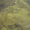
NG51NE 12.4 5903 1652.
Situated on a W-facing slope amongst rough pasture at 20m OD, and shown on the OS maps, is a close group of 5 turf-covered rectangular foundations comprising two houses, two byres and an enclosure.
Visited by M Craik 3 April 1990.

