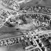
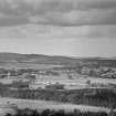
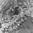
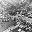
Accessibility

Font Size

100% 150% 200%

Background Colour

Default Contrast
Close Reset

Biggar, General

Burgh (Medieval), Town (Period Unassigned)

Site Name Biggar, General

Classification Burgh (Medieval), Town (Period Unassigned)

Canmore ID 69350

Site Number NT03NW 65

NGR NT 0405 3780

NGR Description Centred on NS 0405 3780

Datum OSGB36 - NGR

Permalink http://canmore.org.uk/site/69350

Ordnance Survey licence number AC0000807262. All rights reserved.
Canmore Disclaimer. © Bluesky International Limited 2025. Public Sector Viewing Terms

Toggle Aerial | View on large map

Digital Images

Oblique aerial view of the housing estate under construction at the NE end of Biggar, looking SE.
Oblique aerial view of the housing estate under construction at the NE end of Biggar, looking SE.Oblique aerial view of Biggar, taken from the WSW.Oblique aerial view of Biggar centred on Biggar Church, churchyard, Moat Park Church and church hall, taken from the SSE.Oblique aerial view of Biggar centred on Biggar Church, churchyard and Moat Park Church, taken from the N.Oblique aerial view of Biggar centred on Biggar Church, churchyard, Moat Park Church and church hall, taken from the NNW.Oblique aerial view of Biggar centred on Biggar Church, churchyard, Moat Park Church and church hall, taken from the SSE.General oblique aerial view centred on the newly constructed Biggar High School, taken from the SSE.Oblique aerial view of Biggar, taken from the ESE.Oblique aerial view of Biggar, taken from the ENE.Oblique aerial view of Biggar, taken from the NNW.Oblique aerial view of Biggar, taken from the W.Oblique aerial view of Biggar centred on Moat Park Church, taken from the NW.Oblique aerial view of Biggar, taken from the ENE.General oblique aerial view centred on the remains of the fort with the churches and churchyard adjacent, taken from the NW.Distant view of Biggar.Oblique aerial view of Biggar centred on the High Street, looking NNE.Oblique aerial view of Biggar, taken from the NNW.Oblique aerial view of Biggar centred on Biggar Church, churchyard and Moat Park Church, taken from the WSW.Oblique aerial view.Oblique aerial view of Biggar centred on Biggar Church, churchyard, Moat Park Church and church hall, taken from the N.Oblique aerial view of Biggar, taken from the E.Oblique aerial view of Biggar, taken from the NE.Oblique aerial view of Biggar centred on Biggar Church, churchyard and Moat Park Church, taken from the NE.General oblique aerial view centred on the remains of the fort with the churches and churchyard adjacent, taken from the S.Oblique aerial view of Biggar, taken from the WSW.Oblique aerial view of Biggar, taken from the WNW.Oblique aerial view of Biggar, taken from the W.Oblique aerial view of Biggar centred on Biggar Church and churchyard, taken from the NW.General oblique aerial view centred on the remains of the fort with the churches and churchyard adjacent, taken from the SE.General oblique aerial view centred on the newly constructed Biggar High School, taken from the S.Oblique aerial view of Biggar centred on Biggar Church, churchyard, Moat Park Church and church hall, taken from the S.Oblique aerial view of Biggar centred on Biggar Church, churchyard, Moat Park Church and church hall, taken from the NNW.Oblique aerial view of Biggar centred on Biggar Church and churchyard, taken from the SW.Oblique aerial view of Biggar centred on Biggar Church, churchyard and Moat Park Church, taken from the SW.Photographic copy of a postcard.
General view of Nelson Bridge and Main Street.
Titled: 'Nelson Bridge and Main Street, Biggar'.Oblique aerial view of Biggar centred on the Corn Exchange, looking WNW.Oblique aerial view of Biggar, taken from the NNE.Oblique aerial view of Biggar centred on Biggar Church and churchyard, taken from the NW.Oblique aerial view of Biggar centred on Biggar Church, churchyard and Moat Park Church, taken from the W.Oblique aerial view of Biggar centred on Moat Park Church, taken from the NW.Oblique aerial view of Biggar centred on Biggar Church, churchyard, Moat Park Church and church hall, taken from the SE.

Administrative Areas

  • Council South Lanarkshire
  • Parish Biggar
  • Former Region Strathclyde
  • Former District Clydesdale
  • Former County Lanarkshire

Archaeology Notes

NT03NW 65 04 37

Erected Burgh of Barony 1451.

G S Pryde 1965.

References

MyCanmore Image Contributions


Contribute an Image

MyCanmore Text Contributions