
Pricing Change
New pricing for orders of material from this site will come into place shortly. Charges for supply of digital images, digitisation on demand, prints and licensing will be altered.
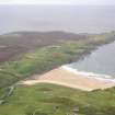
Clash Smeligill


Field System (Period Unassigned), Settlement (Period Unassigned)
Site Name Clash Smeligill
Classification Field System (Period Unassigned), Settlement (Period Unassigned)
Canmore ID 6880
Site Number NC86NW 25
NGR NC 840 655
NGR Description Centred NC 840 655
Datum OSGB36 - NGR
Permalink http://canmore.org.uk/site/6880


- Council Highland
- Parish Farr
- Former Region Highland
- Former District Sutherland
- Former County Sutherland
NC86NW 25 centred 840 655.
NC 8363 6552 - NC 8363 6520. A grass and gorse covered wall 135m long, three to five courses high and 2m wide, running N-S alongside the river and possibly associated with some form of canalisation.
NC 8380 6560. A flagstone wall, 144m long.
NC 8376 6559. An enclosure, 7m by 15m, associated with the above wall
NC 8405 6562. A longhouse, 10m N-S by 5m across, with one wall surviving two to three courses high.
NC 8415 6548. Two longhouses, one measuring 27m NE-SW by 5m across, and the other 23m N-S by 6m across. The former stands 0.6m high and both have internal divisions. An 'L' shaped wall, 14m in all, is associated with them.
NC 8402 6543. Rig and furrow, about 140m wide, running downhill, E-W.
R J Mercer 1981.

