
Following the launch of trove.scot in February 2025 we are now planning the retiral of some of our webservices. Canmore will be switched off on 24th June 2025. Information about the closure can be found on the HES website: Retiral of HES web services | Historic Environment Scotland
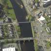
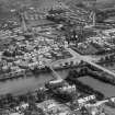
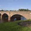
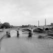
Dumfries, Saint Michael's Bridge


Road Bridge (20th Century)
Site Name Dumfries, Saint Michael's Bridge
Classification Road Bridge (20th Century)
Alternative Name(s) St Michael's Bridge Road; Maxwelltown; River Nith
Canmore ID 68561
Site Number NX97NE 111
NGR NX 97312 75619
Datum OSGB36 - NGR
Permalink http://canmore.org.uk/site/68561


- Council Dumfries And Galloway
- Parish Troqueer (Dumfries-shire)
- Former Region Dumfries And Galloway
- Former District Nithsdale
- Former County Dumfries-shire
NX97NE 111 97312 75619
Location formerly cited as NX 97277 75595 to NX 97336 75335.
St Michael's Bridge [NAT]
OS 1:10,000 map, 1991.
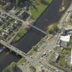
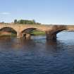
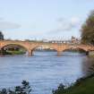
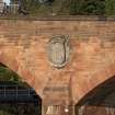
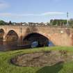
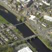
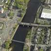
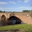
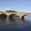
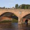
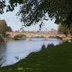
(Location cited as NX 973 757). St Michael's Bridge, built 1927 by engineer J B Brodie. A 4-span, reinforced-concrete bridge 233 ft (70m) long with 3 segmental arches and a smaller semicircular arch over a roadway. Faced with sandstone. There are triangular cutwaters.
J R Hume 1976.
St Michael's Bridge, St Michael's Bridge Road, by J Boyd Brodie, 1925.
J Gifford 1996.
This bridge carries St Michael's Bridge Road across the River Nith to the S of the suspension bridge NX97NE 108. The river here forms the boundary between the parishes of Troqueer (to the W) and Dumfries (to the E).
The location assigned to this record defines the midpoint of the structure. The available map evidence suggests that it extends from NS c. 97281 75600 to NX c. 97334 75637.
Information from RCAHMS (RJCM), 17 March 2006.

