
An Tornaidh Bhuidhe


Monastic Settlement (Period Unassigned)
Site Name An Tornaidh Bhuidhe
Classification Monastic Settlement (Period Unassigned)
Canmore ID 6856
Site Number NC86NE 3
NGR NC 8670 6617
Datum OSGB36 - NGR
Permalink http://canmore.org.uk/site/6856


- Council Highland
- Parish Farr
- Former Region Highland
- Former District Sutherland
- Former County Sutherland
NC86NE 3 8670 6617.
(NC 8670 6617) Torran Buidhe (NAT). Fort (NR) (Remains of)
OS 6"map, Sutherland, 1st ed., (1873)
An Tornaidh Bhuidhe (NAT) Fort (NR)
OS 6"map, (1964)
A large peninsular rock on which there are traces of ruins. There are also remains of a wall and trench which cut off the rock from the land. At the N end the ground is slightly broken and some distance below the surface was found burnt bones, shells and charred wood.
Name Book 1873.
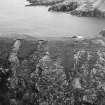
The remains of a promontory fort flanked by precipitous cliffs and approached along a ridge only two or three feet wide in places. The fort consists of a grassy plateau round the edge which runs an earthen rampart or parapet. Down the N face of the cliff is a ledge on which there is a depression but there is no trace of a passage such as that at Dun Mhairtein (NC86NE 1).
RCAHMS 1911, visited 1909.
A cliff-castle.
R J Mercer 1981.
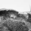
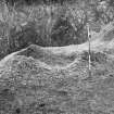
Occupying An Tornaidhe Bhuidhe, a cliff-girt peninsula approached from the S by a restricted arete, is a defensive or protective earthwork enclosing the summit area 47.0m N-S by 10.0m maximum transversely. Around the rim of the summit is a turf-covered bank, at its strongest protecting the approach from the S and along the W side, where it is 0.4m high and spread to a width of 2.0m; it is less strong on the E side and completely eroded on the N and NW. A content of earth and small stones is exposed in the eroded bank. No entrance gap is evident. The interior is largely occupied by a series of irregularly-shaped platforms, probably indicating the sites of buildings. Down the slope to the NE is a small shelf, apparently natural, with a slight bank constructed around the outer side. It may have been a look-out, perhaps later than the main work.
These much eroded remains may be of a promontory fort as stated by the RCAHMS, but it appears more likely to be a Celtic monastic settlement based on (1) the existence of what appear to be the stances for buildings in the interior, and (2) the form of the enclosing bank which appears protective in the manner of a 'vallum monasterii' rather than defensive as in the rampart of an Iron Age fort.
Revised at 1:10,000.
Visited by OS (W D J) 3 May 1960 and (N K B) 28 July 1981.
Note (6 February 2015 - 13 December 2016)
A spectacularly narrow and cliff-girt promontory, accessible only via a razor-backed col from the cliffs on the S, has evidently been enclosed and occupied. From the col the ground rises some 4m to the crest of a low bank that can be traced round the lip of the promontory, enclosing an area measuring about 47m in length and expanding from a narrow point above the col to a maximum of 10m in breadth at the seaward end on the N (0.02ha). Three hollows, variously planned as oval or subrectangular, are set transversely across the broader part of the interior and are probably the footings of buildings; there is also a small terrace cut into the foot of the slope above the cliff-edge at the very tip of the promontory on the N.
Information from An Atlas of Hillforts of Great Britain and Ireland – 13 December 2016. Atlas of Hillforts SC2790

