|
Prints and Drawings |
DFD 166/1 |
|
Photographic copy of plans and elevations for Fiddler's Burn Bridge and bridge near Johnstone Mill. |
1838 |
Item Level |
|
|
Photographs and Off-line Digital Images |
B 5481 |
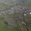
RCAHMS Aerial Photography |
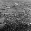
Oblique aerial view of town from SE. |
1988 |
Item Level |
|
|
Photographs and Off-line Digital Images |
C 34411 |
Alastair Maxwell-Irving |
Annan.
Copy of historic photographic view of town from N of bridge.
Insc.: 'Annan, from above the bridge.' |
c. 1910 |
Item Level |
|
|
Photographs and Off-line Digital Images |
C 73644 |
RCAHMS Aerial Photography |
Annan, oblique aerial view, taken from the SW. |
9/8/1996 |
Item Level |
|
|
Photographs and Off-line Digital Images |
C 73645 |
RCAHMS Aerial Photography |
Annan, oblique aerial view, taken from the SSW. |
9/8/1996 |
Item Level |
|
|
Photographs and Off-line Digital Images |
C 73646 |
RCAHMS Aerial Photography |
Annan, oblique aerial view, taken from the SSW. |
9/8/1996 |
Item Level |
|
|
Photographs and Off-line Digital Images |
C 73647 |
RCAHMS Aerial Photography |
Annan, oblique aerial view, taken from the SSW. |
9/8/1996 |
Item Level |
|
 |
On-line Digital Images |
SC 624638 |
RCAHMS Aerial Photography |
Annan, oblique aerial view, taken from the SSW. |
9/8/1996 |
Item Level |
|
|
Photographs and Off-line Digital Images |
DF 1691 |
Records of A Brown and Company, photographers, Lanark, South Lanarkshire, Scotland |
Distant view of Annan |
c. 1925 |
Item Level |
|
|
Photographs and Off-line Digital Images |
DFD 141/1 PO |
General Collection |
Photographic copy of drawing showing survey plan of town. |
1826 |
Item Level |
|
|
Print Room |
UC 7035 |
Royal Incorporation of Architects in Scotland. Nelson. |
Engraving.
General view. |
|
Item Level |
|
|
Prints and Drawings |
DC 1543 |
Historic Scotland. Scottish Burgh Survey. |
Map of Annan in its national and regional settings. Map 1. |
1981 |
Item Level |
|
|
Prints and Drawings |
DC 1544 |
Historic Scotland. Scottish Burgh Survey. |
Map overlay indicating archaeological potential of various areas. Map 2. |
1981 |
Item Level |
|
|
Prints and Drawings |
DC 1545 |
Historic Scotland. Scottish Burgh Survey. |
Map indicating listed buildings, conservation areas and sites of major monuments. Map 3. |
1981 |
Item Level |
|
|
Prints and Drawings |
DC 1546 |
Historic Scotland. Scottish Burgh Survey. |
Working map for DC/1544. |
1981 |
Item Level |
|
|
Prints and Drawings |
DC 1547 |
Historic Scotland. Scottish Burgh Survey. |
Working map for DC/1544. |
1981 |
Item Level |
|
|
Prints and Drawings |
DC 1548 |
Historic Scotland. Scottish Burgh Survey. |
Working map for DC/1545. |
1981 |
Item Level |
|
|
Manuscripts |
MS 307/214 |
Historic Scotland. Scottish Burgh Survey. |
Scottish Burgh Survey Research Material. Draft for publication. |
c. 21/1/1971 |
Item Level |
|
|
Print Room |
PA 44/27/2 |
General Collection. Photograph Albums. |
Distant view of Annan town from south
|
c. 1878 |
Item Level |
|
 |
On-line Digital Images |
DP 030597 |
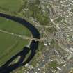
RCAHMS Aerial Photography Digital |
Oblique aerial view centred on the road bridge, taken from the SSW. |
27/4/2007 |
Item Level |
|
|
Print Room |
RAB 332/P25 |
General Collection |
Photograph of general view of Annan from the West, showing the river and a church |
c. 1890 |
Item Level |
|
 |
On-line Digital Images |
DP 077462 |
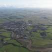
RCAHMS Aerial Photography Digital |
General oblique aerial view centred on the town, taken from the SSW. |
7/4/2010 |
Item Level |
|
 |
On-line Digital Images |
DP 077463 |
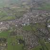
RCAHMS Aerial Photography Digital |
General oblique aerial view centred on the town, taken from the S. |
7/4/2010 |
Item Level |
|
 |
On-line Digital Images |
DP 077464 |
RCAHMS Aerial Photography Digital |
General oblique aerial view centred on the town, taken from the S. |
7/4/2010 |
Item Level |
|


