
Newbarns Smithy


Cropmark(S) (Period Unknown), Linear Feature(S) (Period Unknown), Pit(S) (Period Unknown)
Site Name Newbarns Smithy
Classification Cropmark(S) (Period Unknown), Linear Feature(S) (Period Unknown), Pit(S) (Period Unknown)
Canmore ID 68235
Site Number NO64NE 57
NGR NO 679 492
Datum OSGB36 - NGR
Permalink http://canmore.org.uk/site/68235


- Council Angus
- Parish Inverkeilor
- Former Region Tayside
- Former District Angus
- Former County Angus
NO64NE 57 679 492
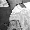
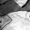
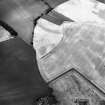
Oblique aerial photographs have revealed a series of linear cropmarks, various other cropmarks and pits in a field surrounding Newbarns Cottages. The majority of these cropmarks are situated in the NW corner of the field.
Information from RCAHMS (KJ) 30 April 1999.
Aerial Photographic Transcription (24 February 1994 - 21 April 1994)
An aerial transcription was produced from oblique aerial photographs. Information from Historic Environment Scotland (BM) 31 March 2017.

