
Pricing Change
New pricing for orders of material from this site will come into place shortly. Charges for supply of digital images, digitisation on demand, prints and licensing will be altered.
Upcoming Maintenance
Please be advised that this website will undergo scheduled maintenance on the following dates:
Thursday, 9 January: 11:00 AM - 3:00 PM
Thursday, 23 January: 11:00 AM - 3:00 PM
Thursday, 30 January: 11:00 AM - 3:00 PM
During these times, some functionality such as image purchasing may be temporarily unavailable. We apologise for any inconvenience this may cause.
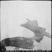
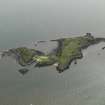
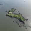
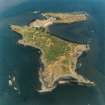
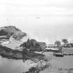
Forth Defences, Middle, Inchcolm


General View (20th Century), Military Installation(S) (20th Century)
Site Name Forth Defences, Middle, Inchcolm
Classification General View (20th Century), Military Installation(S) (20th Century)
Alternative Name(s) Forth Defences; Outer Forth Estuary
Canmore ID 68126
Site Number NT18SE 22
NGR NT 1880 8250
NGR Description Centred NT 1880 8250
Datum OSGB36 - NGR
Permalink http://canmore.org.uk/site/68126


- Council Fife
- Parish Aberdour (Dunfermline)
- Former Region Fife
- Former District Dunfermline
- Former County Fife
The island was first manned for defence on 16 March 1915, when 72 NCOs and men from the Royal Garrison Artillery in Leith crossed to Inchcolm and Inchmickery. On Inchcolm they were to man a battery of eight 12-pdr Quick Firing guns (see NT18SE 22.02) and two or three Defence Electric Lights (powerful searchlights to illuminate targets at night, see see NT18SE 22.08). These guns and lights were explicitly intended to ‘cover’ the anti-submarine boom that controlled access up the Forth from this point. A map of August 1915 (The National Archives WO 78/4417) shows the location of the eight guns, as well as the layout of the men’s accommodation. Two of the guns were placed in the western part of the island (“H” Group) and six in the eastern part, around the summit of that part of the island (“O” Group facing north; “M” Group facing NE and “L” Group facing SE). The Battery Command Post and the Electric Light Director were behind these six guns. The 1915 map shows three electric lights, all in the eastern part of the island, one at the northern corner, at two at the eastern tip.
The defences of the island were reworked as part of a larger-scale reorganisation of the defences of the Forth in 1916-17 in which Inchcolm was to be provided with a far heavier armament. Two of the 12-pdr guns were to be retained (“O” Group). A battery of four 4-inch QF guns was built just in advance of the other 12-pdr emplacements on the east part (“M” and “L”) (see NT18SE 22.01) and at the top of the hill a powerful battery of two 6-inch guns was built (see NT18SE 22.05), along with a new Battery Control Post. In the western part of the island the “H” Group of two 12-pdrs was replaced by four 4.7-inch QF guns (see NT18SE 22.04). The 6-inch guns came from two batteries in England. The 4.7-inch guns came from batteries at Dalmeny and Downing Point, having previously been moved to those batteries from Kinghorn in October 1914. The 4-inch Mk V guns were new. Drawings (The National Archives WO 78/5181) suggest that the 4-inch guns were originally intended to be Mk III, and that drawings had to be amended to alter the emplacements slightly to accommodate more up-to-date Mk V guns and their more modern carriages. The Mk III guns were sent to Inchmickery.
The armament lists for 1916 and 1921 note the the following batteries:
“O” Group - 2x6-inch; 2x12-pdr
“L” & “M” - 4x4-inch [east part of island]
“H” - 4x4.7-inch [west part of island]
By 1921 the names of the groups had changed, although only the No 2 gun of each pair was at that stage being maintained.
Eastern part of island
R1/R2 2x12-pdrs, formerly “O” Group - these guns had been returned to the Navy.
Q1/Q2 2x6-inch guns, formerly also “O” Group
M1/M2 2x4-inch guns
O1/O2 2x4-inch guns
Western part of island
H1/H2 2x4.7-inch guns
L1/L2 2x4.7-inch guns
By 1921 Inchcolm was the site of the Fire Control command for the whole Middle Line of the Forth defence. A Fire Control Post was built on the west part of the island possibly around this time, and used again in the Second World War.
In 1930 the station and its equipment were dismantled: the 6-inch guns were sent to Inchkeith. The 4-inch guns were returned to the depot and the 4.7-inch guns were broken up for scrap.
The island was re-armed in October 1939, when two 12-pdrs were installed on the old 6-inch gun emplacements (see NT18SE 22.10). A twin 6-pdr gun was later installed, supposedly on one of the old 4-inch emplacements, but possibly on a new emplacement (NT18SE 22.01) and various lighter guns (Bofors AA and 2-pdr ‘pom pom’) were installed on the island.
Information from HS/RCAHMS World War One Audit Project (GJB) 16 August 2013.
NT18SE 22 centred 188 825
NT18SE 22.01 NT 19147 82677 and NT 19225 82549 Coast Battery
NT18SE 22.02 NT 19190 82582 and NT 18814 82412 Coast Battery
NT18SE 22.03 centred NT 19200 82570 Coast Battery
NT18SE 22.04 NT 1878 8240 Coast Battery
NT18SE 22.05 NT 19159 82616 and NT 19154 82582 Coast Battery
NT18SE 22.06 centred NT 1880 8250 Military camp
NT18SE 22.07 NT 1871 8241 Gun-emplacement
NT18SE 22.08 NT 19235 82503 and NT 19109 82589 Searchlight Battery
NT18SE 22.09 NT 19163 82700 Searchlight Battery
NT18SE 22.10 NT 19157 82577 Coast Battery
NT18SE 22.11 NT 19177 82585 Tunnel
NT18SE 22.12 centred NT 19019 82693 Military Camp
NT18SE 22.13 NT 19113 82648 Engine House
NT18SE 22.14 NT 19196 82659 Naval Establishment
The remains of several First and Second World War batteries survive on Incholm.
J Guy 1994; NMRS, MS/810/3; PRO WO/192/254.
NT 188 824 and NT 191 826 A watching brief was undertaken in October 2002 on the hilltop during a clearance operation, followed by the partial excavation of a gun emplacement overlooking the Forth in the SW quadrant. The excavation of the gun emplacement suggests that the main structure is broadly intact with relatively little degeneration of the concrete and brick.
Archive to be deposited in the NMRS.
Sponsor: HS
G Ewart 2003
Redfern (Redfern 1998) only notes one battery on Inchcolm, the 12-pounder/6-pounder.
Information from RCAHMS (DE), March 2005
NT 189 826 Monitoring and recording was carried out between January and March 2004 during rubble clearance within the ruins of WW1 and WW2 military structures (see DES 2003, 76). The need for remedial work came from an examination of the old military tunnel that cuts under the hill top at the E end of the island. This WW1 construction contains a vertical shaft at its midpoint, measuring 2.75m along its N-S axis with a width of 2.45m. The shaft had a visible height of 4.95m, at which point it was covered over with large iron plates. The concrete slab over the iron plates sealing the shaft was in reasonable condition and did not seem to be on the verge of collapse.
Archive to be deposited in the NMRS.
Sponsor: HS.
D Stewart 2004.
Watching Brief (10 January 2004 - 6 March 2004)
NT 189 826 Monitoring and recording was carried out between January and March 2004 during rubble clearance within the ruins of WW1 and WW2 military structures (see DES 2003, 76). The need for remedial work came from an examination of the old military tunnel that cuts under the hill top at the E end of the island. This WW1 construction contains a vertical shaft at its midpoint, measuring 2.75m along its N-S axis with a width of 2.45m. The shaft had a visible height of 4.95m, at which point it was covered over with large iron plates. The concrete slab over the iron plates sealing the shaft was in reasonable condition and did not seem to be on the verge of collapse.
D Stewart 2004
Sponsor: Historic Scotland
Kirkdale Archaeology
Project (March 2013 - September 2013)
A project to characterise the quantity and quality of the Scottish resource of known surviving remains of the First World War. Carried out in partnership between Historic Scotland and RCAHMS.

