
Pricing Change
New pricing for orders of material from this site will come into place shortly. Charges for supply of digital images, digitisation on demand, prints and licensing will be altered.
Inverkip Power Station


Power Station (20th Century)
Site Name Inverkip Power Station
Classification Power Station (20th Century)
Alternative Name(s) Inverkip, Power Station And Jetty; Firth Of Clyde
Canmore ID 68124
Site Number NS17SE 5
NGR NS 19670 71030
NGR Description Centred NS 19670 71030
Datum OSGB36 - NGR
Permalink http://canmore.org.uk/site/68124
Ordnance Survey licence number AC0000807262. All rights reserved.
Canmore Disclaimer.
© Bluesky International Limited 2025. Public Sector Viewing Terms
- Correction
- Favourite


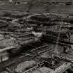
SC 1108250
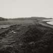
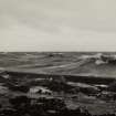
Oblique aerial view centred on the electricity generating station, taken from the NW.
RCAHMS Aerial Photography
22/7/2005
© Crown Copyright: HES

DP 143985
Oblique aerial view of Inverkip Power Station, looking W.
RCAHMS Aerial Photography Digital
11/7/2012
© Crown Copyright: HES

DP 175441
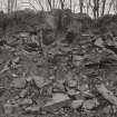
Oblique aerial view of the remains of Inverkip power station during post-demolition clearance, looking to the ENE.
RCAHMS Aerial Photography Digital
30/1/2014
© Crown Copyright: HES

DP 175446
Oblique aerial view of the remains of Inverkip power station during post-demolition clearance, looking to the NNE.
RCAHMS Aerial Photography Digital
30/1/2014
© Crown Copyright: HES

DP 175448
Oblique aerial view of the remains of Inverkip power station during post-demolition clearance, looking to the NNE.
RCAHMS Aerial Photography Digital
30/1/2014
© Crown Copyright: HES


DP 281531
Oblique aerial view.
Historic Environment Scotland
16/7/2018
© Copyright: HES

SC 2144438
Image from photo album titled 'Inverkip'
Scottish Power
23/4/1971
© Courtesy of HES (Scottish Power Collection)

SC 2144439
Image from photo album titled 'Inverkip'
Scottish Power
18/5/1970
© Courtesy of HES (Scottish Power Collection)

SC 2144440
Image from photo album titled 'Inverkip'
Scottish Power
18/5/1970
© Courtesy of HES (Scottish Power Collection)

SC 2144451
Image from photo album titled 'Inverkip'
Scottish Power
18/5/1970
© Courtesy of HES (Scottish Power Collection)

SC 2144459
Image from photo album titled 'Inverkip'
Scottish Power
18/5/1970
© Courtesy of HES (Scottish Power Collection)

SC 2144460
Image from photo album titled 'Inverkip'
Scottish Power
18/5/1970
© Courtesy of HES (Scottish Power Collection)

SC 2144471
Image from photo album titled 'Inverkip'
Scottish Power
18/5/1970
© Courtesy of HES (Scottish Power Collection)

SC 2144473
Image from photo album titled 'Inverkip'
Scottish Power
13/9/1971
© Courtesy of HES (Scottish Power Collection)

SC 2144494
Image from photo album titled 'Inverkip'
Scottish Power
23/4/1971
© Courtesy of HES (Scottish Power Collection)

SC 2144498
Image from photo album titled 'Inverkip'
Scottish Power
23/4/1971
© Courtesy of HES (Scottish Power Collection)

SC 2144514
Image from photo album titled 'Inverkip'
Scottish Power
13/9/1971
© Courtesy of HES (Scottish Power Collection)

SC 2144521
Image from photo album titled 'Inverkip'
Scottish Power
13/9/1971
© Courtesy of HES (Scottish Power Collection)

SC 2144535
Image from photo album titled 'Inverkip'
Scottish Power
13/9/1971
© Courtesy of HES (Scottish Power Collection)

SC 2144562
Image from photo album titled 'Inverkip'
Scottish Power
18/11/1971
© Courtesy of HES (Scottish Power Collection)

SC 2144573
Image from photo album titled 'Inverkip'
Scottish Power
18/11/1971
© Courtesy of HES (Scottish Power Collection)

SC 2144578
Image from photo album titled 'Inverkip'
Scottish Power
18/11/1971
© Courtesy of HES (Scottish Power Collection)

SC 2144586
Image from photo album titled 'Inverkip'
Scottish Power
18/11/1971
© Courtesy of HES (Scottish Power Collection)

SC 2144601
Image from photo album titled 'Inverkip'
Scottish Power
18/11/1971
© Courtesy of HES (Scottish Power Collection)

SC 2144609
Image from photo album titled 'Inverkip'
Scottish Power
18/11/1971
© Courtesy of HES (Scottish Power Collection)

SC 2144614
Image from photo album titled 'Inverkip'
Scottish Power
18/11/1971
© Courtesy of HES (Scottish Power Collection)

SC 2144624
Image from photo album titled 'Inverkip'
Scottish Power
18/11/1971
© Courtesy of HES (Scottish Power Collection)

SC 2144627
Image from photo album titled 'Inverkip'
Scottish Power
18/11/1971
© Courtesy of HES (Scottish Power Collection)

SC 2144628
Image from photo album titled 'Inverkip'
Scottish Power
18/11/1971
© Courtesy of HES (Scottish Power Collection)

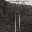
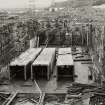
SC 2144630
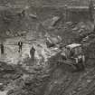
Image from photo album titled 'Inverkip', No. KP 150A, C.W. pumphouse - cofferdam showing rock anchors
Scottish Power
14/3/1972
© Courtesy of HES (Scottish Power Collection)

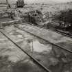
SC 2144637
Image from photo album titled 'Inverkip', No. KP 165A, Admin. building foundations
Scottish Power
14/3/1972
© Courtesy of HES (Scottish Power Collection)

SC 2144643
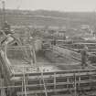
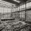
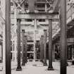
Image from photo album titled 'Inverkip', No. KP 170A, Turbine House No. 3 T/G site area
Scottish Power
14/3/1972
© Courtesy of HES (Scottish Power Collection)

SC 2144644
Image from photo album titled 'Inverkip', No. KP 172A, Auxiliary Boiler house foundations
Scottish Power
11/4/1972
© Courtesy of HES (Scottish Power Collection)

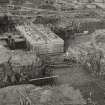
SC 2144646
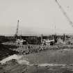
Image from photo album titled 'Inverkip', No. KP 174A, C.W. Pumphouse - Rock anchors stressing plinth
Scottish Power
11/4/1972
© Courtesy of HES (Scottish Power Collection)

SC 2144647
Image from photo album titled 'Inverkip', No. KP 175A, C.W. Pumphouse - Cofferdam
Scottish Power
11/4/1972
© Courtesy of HES (Scottish Power Collection)

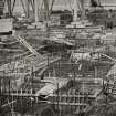
SC 2144649
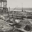
Image from photo album titled 'Inverkip', No. KP 177A, Boiler House Column Foundations
Scottish Power
11/4/1972
© Courtesy of HES (Scottish Power Collection)

SC 2144664
Image from photo album titled 'Inverkip', No. KP 190, Admin. & Welfare building foundations & Boiler House steelwork
Scottish Power
11/4/1972
© Courtesy of HES (Scottish Power Collection)

SC 2144670
Image from photo album titled 'Inverkip', No. KP 196, Turbine House foundations - No. 2 T/G areas
Scottish Power
11/4/1972
© Courtesy of HES (Scottish Power Collection)

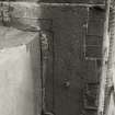
SC 2144672
Image from photo album titled 'Inverkip', No. KP 154A, Control building - reinforced concrete beam
Scottish Power
14/3/1972
© Courtesy of HES (Scottish Power Collection)

SC 2144684
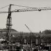
Image from photo album titled 'Inverkip'
Scottish Power
5/1972
© Courtesy of HES (Scottish Power Collection)

SC 2144696
Image from photo album titled 'Inverkip'
Scottish Power
5/1972
© Courtesy of HES (Scottish Power Collection)

SC 2144701
Image from photo album titled 'Inverkip'
Scottish Power
5/1972
© Courtesy of HES (Scottish Power Collection)

SC 2144707
Image from photo album titled 'Inverkip'
Scottish Power
10/8/1974
© Courtesy of HES (Scottish Power Collection)

SC 2144725
Image from photo album titled 'Inverkip'
Scottish Power
6/1974
© Courtesy of HES (Scottish Power Collection)

SC 2144728
Image from photo album titled 'Inverkip'
Scottish Power
6/1974
© Courtesy of HES (Scottish Power Collection)

SC 2144730
Image from photo album titled 'Inverkip'
Scottish Power
6/1974
© Courtesy of HES (Scottish Power Collection)

SC 2144751
Image from photo album titled 'Inverkip'
Scottish Power
6/1974
© Courtesy of HES (Scottish Power Collection)

SC 2144756
Image from photo album titled 'Inverkip'
Scottish Power
6/1974
© Courtesy of HES (Scottish Power Collection)

SC 2144759
Image from photo album titled 'Inverkip'
Scottish Power
6/1974
© Courtesy of HES (Scottish Power Collection)

SC 2144765
Image from photo album titled 'Inverkip'
Scottish Power
27/8/1974
© Courtesy of HES (Scottish Power Collection)

SC 2144786
Image from photo album titled 'Inverkip'
Scottish Power
27/8/1974
© Courtesy of HES (Scottish Power Collection)

SC 2144797
Image from photo album titled 'Inverkip'
Scottish Power
10/8/1974
© Courtesy of HES (Scottish Power Collection)

SC 2144803
Image from photo album titled 'Inverkip'
Scottish Power
10/8/1974
© Courtesy of HES (Scottish Power Collection)

SC 2144805
Image from photo album titled 'Inverkip'
Scottish Power
10/8/1974
© Courtesy of HES (Scottish Power Collection)

SC 2144809
Image from photo album titled 'Inverkip'
Scottish Power
10/8/1974
© Courtesy of HES (Scottish Power Collection)

SC 2144830
Image from photo album titled 'Inverkip'
Scottish Power
5/11/1974
© Courtesy of HES (Scottish Power Collection)

SC 2144834
Image from photo album titled 'Inverkip'
Scottish Power
5/11/1974
© Courtesy of HES (Scottish Power Collection)

SC 2144838
Image from photo album titled 'Inverkip'
Scottish Power
5/11/1974
© Courtesy of HES (Scottish Power Collection)

SC 2144839
Image from photo album titled 'Inverkip'
Scottish Power
5/11/1974
© Courtesy of HES (Scottish Power Collection)

SC 2144842
Image from photo album titled 'Inverkip'
Scottish Power
5/11/1974
© Courtesy of HES (Scottish Power Collection)

SC 2144858
Image from photo album titled 'Inverkip'
Scottish Power
4/2/1975
© Courtesy of HES (Scottish Power Collection)

SC 2144870
Image from photo album titled 'Inverkip'
Scottish Power
4/2/1975
© Courtesy of HES (Scottish Power Collection)

SC 2144878
Image from photo album titled 'Inverkip'
Scottish Power
4/2/1975
© Courtesy of HES (Scottish Power Collection)

SC 2144904
Image from photo album titled 'Inverkip'
Scottish Power
27/5/1975
© Courtesy of HES (Scottish Power Collection)

SC 2144914
Image from photo album titled 'Inverkip'
Scottish Power
27/5/1975
© Courtesy of HES (Scottish Power Collection)

SC 2144916
Image from photo album titled 'Inverkip'
Scottish Power
27/5/1975
© Courtesy of HES (Scottish Power Collection)

SC 2144926
Image from photo album titled 'Inverkip'
Scottish Power
27/5/1975
© Courtesy of HES (Scottish Power Collection)

SC 2144931
Image from photo album titled 'Inverkip'
Scottish Power
27/5/1975
© Courtesy of HES (Scottish Power Collection)

SC 2144935
Image from photo album titled 'Inverkip'
Scottish Power
27/5/1975
© Courtesy of HES (Scottish Power Collection)

SC 2144936
Image from photo album titled 'Inverkip'
Scottish Power
27/5/1975
© Courtesy of HES (Scottish Power Collection)

SC 2159466
Image from untitled photo album
Scottish Power
27/5/1971
© Courtesy of HES (Scottish Power Collection)

SC 2159467
Image from untitled photo album
Scottish Power
27/5/1971
© Courtesy of HES (Scottish Power Collection)

SC 2159479
Image from untitled photo album
Scottish Power
27/5/1971
© Courtesy of HES (Scottish Power Collection)

SC 2159485
Image from untitled photo album
Scottish Power
27/5/1971
© Courtesy of HES (Scottish Power Collection)

SC 2164717
Image from photo album titled 'Inverkip Power Station'
Scottish Power
© Courtesy of HES (Scottish Power Collection)

SC 2164730
Image from photo album titled 'Inverkip Power Station'
Scottish Power
© Courtesy of HES (Scottish Power Collection)

SC 2164744
Image from photo album titled 'Inverkip Power Station'
Scottish Power
© Courtesy of HES (Scottish Power Collection)

SC 2164749
Image from photo album titled 'Inverkip Power Station'
Scottish Power
© Courtesy of HES (Scottish Power Collection)

SC 2164753
Image from photo album titled 'Inverkip Power Station'
Scottish Power
© Courtesy of HES (Scottish Power Collection)

SC 2164759
Image from photo album titled 'Inverkip Power Station'
Scottish Power
© Courtesy of HES (Scottish Power Collection)

SC 2164766
Image from photo album titled 'Inverkip Power Station'
Scottish Power
© Courtesy of HES (Scottish Power Collection)

SC 2164781
Image from photo album titled 'Inverkip Power Station'
Scottish Power
© Courtesy of HES (Scottish Power Collection)

DP 175447
Oblique aerial view of the remains of Inverkip power station during post-demolition clearance, looking to the NE.
RCAHMS Aerial Photography Digital
30/1/2014
© Crown Copyright: HES

DP 237276
Oblique aerial view.
Historic Environment Scotland
5/7/2016
© Copyright: HES

SC 2144450
Image from photo album titled 'Inverkip'
Scottish Power
18/5/1970
© Courtesy of HES (Scottish Power Collection)

SC 2144458
Image from photo album titled 'Inverkip'
Scottish Power
18/5/1970
© Courtesy of HES (Scottish Power Collection)

SC 2144461
Image from photo album titled 'Inverkip'
Scottish Power
18/5/1970
© Courtesy of HES (Scottish Power Collection)

SC 2144466
Image from photo album titled 'Inverkip'
Scottish Power
18/5/1970
© Courtesy of HES (Scottish Power Collection)

SC 2144468
Image from photo album titled 'Inverkip'
Scottish Power
18/5/1970
© Courtesy of HES (Scottish Power Collection)

SC 2144478
Image from photo album titled 'Inverkip'
Scottish Power
23/4/1971
© Courtesy of HES (Scottish Power Collection)

SC 2144484
Image from photo album titled 'Inverkip'
Scottish Power
23/4/1971
© Courtesy of HES (Scottish Power Collection)

SC 2144487
Image from photo album titled 'Inverkip'
Scottish Power
23/4/1971
© Courtesy of HES (Scottish Power Collection)

SC 2144497
Image from photo album titled 'Inverkip'
Scottish Power
23/4/1971
© Courtesy of HES (Scottish Power Collection)

SC 2144499
Image from photo album titled 'Inverkip'
Scottish Power
23/4/1971
© Courtesy of HES (Scottish Power Collection)

SC 2144506
Image from photo album titled 'Inverkip'
Scottish Power
18/11/1971
© Courtesy of HES (Scottish Power Collection)

SC 2144522
Image from photo album titled 'Inverkip'
Scottish Power
13/9/1971
© Courtesy of HES (Scottish Power Collection)

SC 2144543
Image from photo album titled 'Inverkip'
Scottish Power
13/9/1971
© Courtesy of HES (Scottish Power Collection)


First 100 images shown. See the Collections panel (below) for a link to all digital images.
- Council Inverclyde
- Parish Inverkip
- Former Region Strathclyde
- Former District Inverclyde
- Former County Renfrewshire
NS17SE 5.00 centred 19670 71030
Power Station [NAT]
OS 1:10,000 map, 1980.
Location formerly entered as NS 196 710.
NS17SE 5.01 NS 18876 70884 to NS 19123 70804 Jetty

