Pricing Change
New pricing for orders of material from this site will come into place shortly. Charges for supply of digital images, digitisation on demand, prints and licensing will be altered.
Ninestone Rig
Stone Circle (Neolithic) - (Bronze Age)
Site Name Ninestone Rig
Classification Stone Circle (Neolithic) - (Bronze Age)
Alternative Name(s) Nine Stones; Ninestane Rig
Canmore ID 67994
Site Number NY59NW 6
NGR NY 5175 9731
Datum OSGB36 - NGR
Permalink http://canmore.org.uk/site/67994
- Council Scottish Borders, The
- Parish Castleton
- Former Region Borders
- Former District Roxburgh
- Former County Roxburghshire
NY59NW 6 5180 9731.
(NY 5180 9731) Nine Stones (Stone Circle) (NR)
OS 6" map (1923)
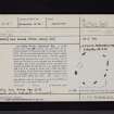
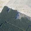
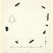
Stone Circle, Ninestone Rig. A small stone circle stands 290 yds. SSE by S of the summit of Ninestone Rig, at a height of 910 ft. OD. There are eight earthfast stones, while a ninth has fallen inwards and lies prone. All the upright stones lean inwards but seem to be in situ; six of them are broken to mere stumps, not exceeding 2 ft. in height, and of the remainder one (C on plan) is a regular monolith measuring 6 ft. 4 in. along its upper and 5 ft. 8 in. along its under side, while the other (A on plan), which leans less sharply, measures 4 ft. 4 in. in height and has a chisel-shaped outline when viewed from within the circle. The "circle" is in fact slightly oval, as it measures 23 ft. from ENE to WSW and 21 ft. from NW to SE.
RCAHMS 1956, visited 1948
Probably Early Bronze Age.
Information from OS Recorder (KH) 28 September 1956
As described above.
Visited by OS (JLD) 28 September 1960.
Scheduled as Nine Stones, stone circle, Ninestone Rig.
Information from Historic Scotland, scheduling document dated 23 January 2002.
Sbc Note (15 April 2016)
Visibility: Standing structure or monument.
Information from Scottish Borders Council


