
Foulshiels


Settlement (Later Prehistoric)
Site Name Foulshiels
Classification Settlement (Later Prehistoric)
Canmore ID 67920
Site Number NY49SE 2
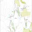
NGR NY 4935 9096
Datum OSGB36 - NGR
Permalink http://canmore.org.uk/site/67920


- Council Scottish Borders, The
- Parish Castleton
- Former Region Borders
- Former District Roxburgh
- Former County Roxburghshire
NY49SE 2 4935 9096.
(NY 4935 9096) Ancient Earthwork (NAT)
OS 6" map (1957)
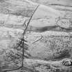
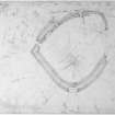
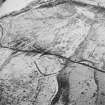
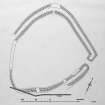
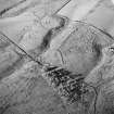
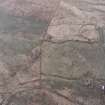
This earthwork, which may be a homestead moat, lies on the gentle E slope of Foulshiels Rig at a height of 480 ft OD. Subrectangular on plan, it measures 285 ft N-S by 270 ft transversely and consists of a ditch with an earthen bank on either side; the outer bank has been destroyed along the SE, S, SW and W sides by drainage and cultivation, which have also created a gap of 105 ft in the W side of the inner bank. The banks, where best preserved, on the NW side, are each 3 1/2 ft in height and 14 ft in width; the shallow ditch is 8 ft wide. At either side of the entrance (in the E corner) the banks join after turning the ends of the ditch, leaving a passage 10 ft wide.
The interior is marshy; drains have been dug through the inner bank at several points. The only internal feature is a low, irregular mound, about 50 ft in diameter, which lies in the SW sector.
RCAHMS 1956, visited 1949
This denuded earthwork is generally as described and planned by the RCAHMS. Only natural swellings were noted in the SW quadrant, although there is a vague levelled area across the N side, the purpose and origin of which is not clear. The overall size and construction technique are not typical of a medieval moat, and the ditch, at varying levels, was never waterfilled. The work has closer parallels with local probable settlements such as NY58SW 7 and NY58NW 3.
Surveyed at 1:10,000.
Visited by OS (JRL) 24 August 1979
Field Visit (25 March 1996)
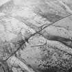
This settlement is situated on a terrace about 200m SSW of Foulshiels steading. D-shaped on plan, it measures 85m from NNE to SSW by 68.5m transversely within a stony rampart about 3.3m in thickness and up to 0.8m in height. The rampart is accompanied by an external ditch up to 3.5m in breadth and about 0.7m in depth, and there is an entrance on the ESE, near the E corner, with a causeway across the ditch. Although various platforms or terraces and rickles of stones can be seen in the interior, none can be resolved into coherent structures, either circular or rectangular. Two other gaps in the perimeter are visible, one on the SE and the other at the NNW corner. On the SW there is a boggy hollow across which it is difficult to trace either the rampart or the ditch.
(LID96 52)
Visited by RCAHMS (PJD) 25 March 1996
Field Visit (1996 - 2003)
Russell Coleman managed an Historic Scotland funded project to record medieval moated sites in Scotland. Gazetteers were produced for each regional council area between 1996 and 2002 with an uncompleted overall review in 2002-03. The results of the first year of the project were published in Tayside and Fife Archaeological Journal, Volume 3 (1997).
Sbc Note
Visibility: This is an upstanding earthwork or monument.
Information from Scottish Borders Council

