
Pricing Change
New pricing for orders of material from this site will come into place shortly. Charges for supply of digital images, digitisation on demand, prints and licensing will be altered.
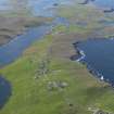
West Burra, Southerhouse, Chapel


Chapel (Medieval)(Possible)
Site Name West Burra, Southerhouse, Chapel
Classification Chapel (Medieval)(Possible)
Canmore ID 678
Site Number HU33SE 9
NGR HU 3784 3492
Datum OSGB36 - NGR
Permalink http://canmore.org.uk/site/678


- Council Shetland Islands
- Parish Lerwick
- Former Region Shetland Islands Area
- Former District Shetland
- Former County Shetland
HU33SE 9 3784 3492.
( HU 3784 3494 ) Chapel (L.B.) (Site of).
OS 6" map, Shetland, 2nd ed. (1903)
The reputed site of an old chapel which was altogether ruinous (R Sibbald 1711) in 1711.
RCAHMS 1946, visited 1930
Apart from slight ground disturbance at the site, no trace was seen or local knowledge found of a chapel.
Visited by OS(AA) 15 May 1968
Field Visit (26 July 1930)
Chapel, Southerhouse. On the E side of the public road, between the houses and garden enclosures of the small townships of Brough and Southerhouse, is a vacant space which is reputed to be the site of an old chapel. No traces of a building can now be discerned, and even in Sibbald's time the chapel had ‘become altogether ruinous’*.
RCAHMS 1946, visited 26 July 1930.
OS 6" map, Shetland, 2nd ed. (1903)
*Sibbald, Description, p. 26: Cf. also P.S.A.S., xv (1880-1), p. 206, and xlvi (1911-2), p. 125.

