
Cleuchfoot


Palisaded Settlement (Prehistoric), Unenclosed Settlement (Prehistoric)
Site Name Cleuchfoot
Classification Palisaded Settlement (Prehistoric), Unenclosed Settlement (Prehistoric)
Alternative Name(s) Tansy Hill
Canmore ID 67745
Site Number NY38SW 8
NGR NY 31473 83420
Datum OSGB36 - NGR
Permalink http://canmore.org.uk/site/67745


- Council Dumfries And Galloway
- Parish Langholm
- Former Region Dumfries And Galloway
- Former District Annandale And Eskdale
- Former County Dumfries-shire
Remains of later prehistoric settlement located on south-east facing terrace of Tansy Hill above Logan Water in rough pasture. Main views along Logan valley to south and across towards other related sites on western valley sides.
information from Héléna Gray, (CFA Archaeology Ltd), August 2015
OASIS ID: cfaarcha1-278420
Field Visit (March 1981)
Cleuchfoot NY 314 834 NY38SW
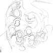
What is probably a settlement of unenclosed timber houses is situated on gently sloping ground 600m N of Cleuchfoot farmhouse. There are at least four house-sites, measuring between 7.5m and 9.1 m in diameter overall, and all defined by shallow grooves up to 0.9m broad; arcs of shallow ditches (not more than 2.3m broad and 0.3m deep) and a water-logged hollow (8.2m in diameter and 0.5m in depth) may indicate the sites of five other houses. Around the NW and SW of the settlement there is a shallow groove, which resembles the surface-remains of a palisade trench, but which may be no more than a drainage gully.
RCAHMS 1981, visited March 1981
Measured Survey (29 April 1992 - 3 March 1993)
RCAHMS surveyed the unenclosed settlement at Cleuchfoot with plane-table and self-reducing alidade at a scale of 1:250. The survey was undertaken over three visits between 29 April – 1 May 1992, 15-16 February 1993 and 3 March 1993. The plan was redrawn in ink and published at a scale of 1:500 (RCAHMS 1997, Fig. 115).
Field Visit (19 February 1993)
NY 3149 8341 NY38SW 8
The well-preserved remains of this multi-period complex of round timber houses (formerly classified as Settlement and Cultivation Remains) are situated some 600m N of Cleuchfoot steading (NY38SW 64.00) on the SW shoulder of Tansy Hill. The settlement lies on a S-facing slope in pasture and the NE corner has been disturbed in recent times by the digging of drains. At least twenty structures of ring-ditch and ring-groove type are represented and, whilst it is clear that evidence for successive phases of construction is present (sequences of at least four and possibly as many as seven structures can be inferred on the W side of the settlement), little sense with regard to the development of the settlement as a whole can be construed. However, at least two of the structures on the NW, a ring-ditch and a succeeding ring-groove, are earlier than a probable palisade trench which can be traced for a length of about 60m on the W and possibly for a very short stretch on the NE. Building-types include ring-ditch houses measuring up to about 7m in overall diameter, with evidence of a ring-groove on the outer lip of the ditch, and also ring-groove houses from 6m to 8m in internal diameter; two examples of simple platforms with a ring-groove around the top of their back scarps, may be poorly preserved examples of ring-ditch-type buildings structures.
Visited by RCAHMS (JRS), 19 February 1993.
Listed as timber round-houses and palisaded enclosure.
RCAHMS 1997.
Project (29 May 2014)
An archaeological evaluation was undertaken by CFA Archaeology Ltd, a desk based assessment and walk over survey (May 29th 2014) was conducted
The historic environment record within the Site Boundary is relatively limited, although there is some potential for the proposed development site to contain previously unknown heritage assets from at least the later prehistoric period onwards, given the historic landscape character of the wider area. Taking this into account, the archaeological potential of the proposed development site is considered to be low.
A summary assessment, on a site by site basis, of the predicted effects on the settings of assets within a 10km radius where the blade tip ZTV indicates that there would be theoretical views of one or more turbines
information from Héléna Gray, (CFA Archaeology Ltd), August 2015
OASIS ID: cfaarcha1-278420
Project (22 November 2017 - 28 November 2017)
A historic environment assessment and survey was required by Buccleuch Eskdale & Liddesdale Estate to inform a programme of tree planting across a number of areas at Cleuchfoot Farm, Langholm, Dumfries and Galloway centered on NY 32343 83556. These works were designed to inform on the nature, form and extent of any historic environment assets present within the defined area based on archival sources and site inspection through the walkover survey. From this baseline, management guidelines are presented that seek to protect significant sites in an appropriate setting.
This process identified fifteen historic environment sites relating to the assessment area, 9 of which were protected for their significance.
Information from Rathmell Archaeology Ltd.

