Accessibility

Font Size

100% 150% 200%

Background Colour

Default Contrast
Close Reset

Tarrasfoot Viaduct

Railway Viaduct (19th Century) - (20th Century)

Site Name Tarrasfoot Viaduct

Classification Railway Viaduct (19th Century) - (20th Century)

Alternative Name(s) Hinds Hole; Tarras Water; Glen Tarras

Canmore ID 67700

Site Number NY38SE 51

NGR NY 37897 81054

Datum OSGB36 - NGR

Permalink http://canmore.org.uk/site/67700

Ordnance Survey licence number AC0000807262. All rights reserved.
Canmore Disclaimer. © Bluesky International Limited 2025. Public Sector Viewing Terms

Toggle Aerial | View on large map

Digital Images

Tarrasfoot Viaduct. Detail of trench in deck to be used for demolition charges.
Tarrasfoot Viaduct. Detail of trench in deck to be used for demolition charges.Viaduct, Glen Tarras, Canonbie ParishTarrasfoot Viaduct. View from E.Detail of spans and springers on SW elevation from SE bank.Tarrasfoot Viaduct. View from NE.Tarrasfoot Viaduct. View from W.Tarrasfoot Viaduct. View of SW elevation from SE bank.Tarrasfoot Viaduct. View from WSW.Tarrasfoot Viaduct. View from ENE.Viaduct, Glen Tarras, Canonbie ParishTarrasfoot Viaduct
View from ETarrasfoot Viaduct. View from NE.Tarrasfoot Viaduct. Detail of 'Dewar' brick from the arch voussoirs or linings.Detail of trench in deck to be used for demolition charges.Tarrasfoot Viaduct. View along deck from SE.Tarrasfoot Viaduct. View from E.Tarrsfoot Viaduct. View from NE.Tarrasfoot Viaduct. Detail of drain pipe and reinforcing cast iron wall plate in spandrel.Tarrasfoot Viaduct. View of SW elevation from SE bank.Tarrasfoot Viaduct. Detail of 'Dewar' brick from the arch voussoirs or linings.Tarrasfoot Viaduct. View from E.Viaduct, Glen Tarras, Canonbie ParishTarrasfoot viaduct. Detail of drain pipe and reinforcing cast iron wall plate in spandrel.Tarrasfoot Viaduct. Detail of pier and brick voussoirs from SE on SW elevation, SE bank.Tarrasfoot Viaduct. View from WSW.Tarrasfoot Viaduct. Detail of pier and brick voussoirs from SE on SW elevation, SE bank.Tarrasfoot Viaduct. View from WSW.Tarrasfoot Viaduct. View from W.Tarrasfoot Viaduct. View from WSW.Tarrasfoot Viaduct. View along deck from SE.Tarrasfoot Viaduct. Detail of spans and springers on SW elevation from SE bank.View from SE.Tarrasfoot Viaduct. View from ENE.Viaduct, Glen Tarras, Canonbie ParishTarrasfoot Viaduct, NY38SE 51, Ordnance Survey index card, RectoView from NE.View from ESE.View from W.View from SE of underside of arches on SW elevation.Tarrasfoot Viaduct. Detail of trench in deck to be used for demolition charges.Tarrasfoot Viaduct. Detail of spans and springers on SW elevation from SE bank.

Administrative Areas

  • Council Dumfries And Galloway
  • Parish Langholm
  • Former Region Dumfries And Galloway
  • Former District Annandale And Eskdale
  • Former County Dumfries-shire

Archaeology Notes

NY38SE 51 37897 81054

Location formerly cited as NY 3782 8111 to NY 3795 8099.

For corresponding road bridge (upstream, to NE), see NY38SE 249.

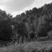
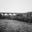
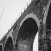
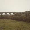
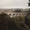
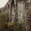
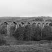
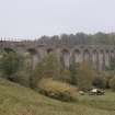
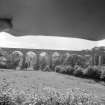
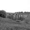
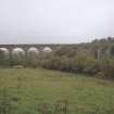
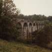
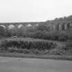
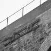
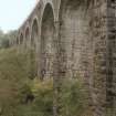
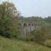
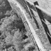
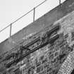
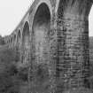
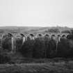
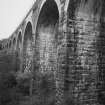
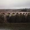
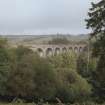
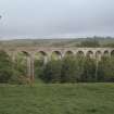
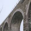
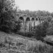
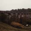
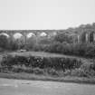
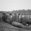
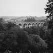
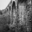
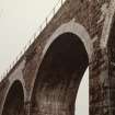
(Location cited as NY 379 810). Viaduct, Tarrasfoot. Opened 1864 by the Border Union Rly. A 12-span masonry structure with semicircular arches, now disused.

J R Hume 1976.

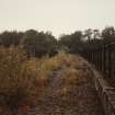
This viaduct carried the Riddings Junction (Waverley route) to Langholm branch of the North British Railway (grouped into the London and North Eastern Rly.) across the Tarras Water to the N of Tarrasfoot steading (NY38SE 78). The river here forms the boundary between the parishes of Canonbie (to the SE) and Langholm (to the NW).

The branch opened on 18th April 1864, and closed to regular passenger traffic on 15 June 1964.

Information from RCAHMS (RJCM), 21 March 1996.

J Thomas 1971; G Daniels and L Dench 1980.

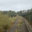
This viaduct has been demolished [date unknown].

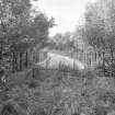
The location assigned to this record defines the midpoint of the structure. The available map evidence indicates that it extends from NY c. 37830 81121 to NY c. 37947 80997.

Information from RCAHMS (RJCM), 20 March 2006.

Activities

Photographic Survey (30 September 1986)

Photographic survey by RCAHMS in September 1986.

References

MyCanmore Image Contributions


Contribute an Image

MyCanmore Text Contributions