
Barntalloch Castle, Staplegordon


Castle (Medieval), Motte And Bailey (Medieval), Rig And Furrow (Medieval) - (Post Medieval)
Site Name Barntalloch Castle, Staplegordon
Classification Castle (Medieval), Motte And Bailey (Medieval), Rig And Furrow (Medieval) - (Post Medieval)
Alternative Name(s) Staplegordon Motte; Staplegorton; River Esk; Staplegordon Burn; Portholm Pool; Potholm
Canmore ID 67601
Site Number NY38NE 4
NGR NY 3525 8776
Datum OSGB36 - NGR
Permalink http://canmore.org.uk/site/67601


- Council Dumfries And Galloway
- Parish Langholm
- Former Region Dumfries And Galloway
- Former District Annandale And Eskdale
- Former County Dumfries-shire
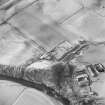
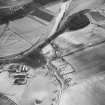
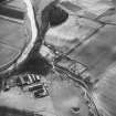
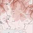
Remains of medieval motte and bailey, and later castle, visible as an earthwork and upstanding ruin located on a cliff forming north bank of River Esk at confluence with Staplegordon Burn. Located within improved rural landscape and partially overlain by mature trees. Distant views restricted by rising topography of surrounding valley sides.
information from Héléna Gray, (CFA Archaeology Ltd), August 2015
NY38NE 4 3525 8776.
(NY 3525 8776) Barntalloch Castle (NR) (Site of)
OS 6" map (1957)
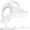
The original feature at this site is a motte and bailey erected by Galfrid or Geoffrey de Coningsburgh in the second half of the 12th century. The site is defended by cliffs overlooking the River Esk on the S, and a deep glen cut by Staplegordon Burn on the E. A ditch, 40ft wide and 9ft deep, cuts off the promontory, an area which today measures 100ft by 80ft, having been reduced by erosion. The material from the ditch has been used to level the promontory. Outwith the ditch, a large area of level ground was enclosed by a rampart and palisade, forming a bailey.
The de Coningsburgh family disappears about 1280, and Sir John Lindsay, Chamberlain of Scotland, had acquired the land by 1285. Perhaps it was he, rather than the former, who erected a stone castle on the motte; it was then known as Barntalloch Castle.
Chalmers (G Chalmers 1890) records the tradition that it was 'of round form' and Reid states that it has long ago fallen into the river and been swept away. The RCAHMS, however, note foundations, in the SW angle of the motte, 3 3/4ft thick, of a rectangular building 20ft broad, believed to be the remains of a later tower. Above the ditch of the motte is a mound which appears to contain stone work, possibly connected with the tower, and there are traces of a parapet mound along the N face.
There is now no trace of the early burgh of Staplegorton, associated with this castle, for which see NY38NE 27.
R C Reid 1954; RCAHMS 1920, visited 1912
The remains of Barntalloch Castle are generally as described above. The motte is 1.7m above the ditch bottom and the bailey 1.0m. The N angle of a structure on the motte survives to a height of 0.7m, and a small shallow pit about 2.0m in diameter and of unknown date and purpose lies on the south side of the motte, otherwise the level top is featureless. Surveyed at 1/2500.
Visited by OS (JB) 2 October 1979.
Field Visit (November 1980)
Barntalloch Castle, Staplegordon NY 352 877 NY38NE 4
A steep-sided promontory 120m SSE of Staplegordon Burial-ground (NY38NE 2) has been cut off by a ditch (12m broad) to form a motte (27m by 21m) which has a fragment of mortared masonry on its leading edge. On the W there is a bailey (51m by 42m).
RCAHMS 1981, visited November 1980
(Hyslop and Hyslop, 1912, 321-2; RCAHMS 1920, p. 146, No. 431; Reid 1953)
Field Visit (1991)
NY 3525 8776 NY38NE 4
This motte-and-bailey castle is situated on a steep-sided promontory 120m SSE of Staplegordon burial-ground (NY38NE 2). The motte has been formed from the E tip of the promontory and is defended on the W by a ditch up to 12.5m broad.; the triangular top of the motte measures 27m from ESE to WNW by 26m transversely and a fragment of mortared masonry is visible on its leading (W) edge.
The bailey lies to the W and measures up to 57m from NE to SW by 37m transversely internally. It is defended on the S by the steep natural drop down to the river, but on the N and W there is a low rampart which has been spread up to 4m in thickness; the flanks of the promontory appear to have been scarped down to the level of the terrace that can be traced along the foot of the slope. The entrance to the bailey lies on the W but access to the motte may have been provided by a timber bridge spanning the ditch at the NE corner of the bailey, opposite which there is slight evidence of an entrance-way leading up to the summit.
The interior of the bailey has been cultivated, and traces of rig-and-furrow cultivation, culminating in a plough-scar, encroach on the foot of the bailey, on the N.
Visited by RCAHMS (IMS, PC, SH), June 1991.
Listed as motte and bailey.
RCAHMS 1997.
Measured Survey (8 April 1992)
RCAHMS surveyed the motte and bailey at Barntalloch Castle (Staplegordon) on 8 April 1992 with plane-table and self-reducing alidade at a scale of 1:500. The plan was redrawn in ink and published at a scale of 1:2500 (RCAHMS 1997, Fig. 202).
Project (29 May 2014)
An archaeological evaluation was undertaken by CFA Archaeology Ltd, a desk based assessment and walk over survey (May 29th 2014) was conducted
The historic environment record within the Site Boundary is relatively limited, although there is some potential for the proposed development site to contain previously unknown heritage assets from at least the later prehistoric period onwards, given the historic landscape character of the wider area. Taking this into account, the archaeological potential of the proposed development site is considered to be low.
A summary assessment, on a site by site basis, of the predicted effects on the settings of assets within a 10km radius where the blade tip ZTV indicates that there would be theoretical views of one or more turbines
information from Héléna Gray, (CFA Archaeology Ltd), August 2015
OASIS ID: cfaarcha1-278420

