 |
On-line Digital Images |
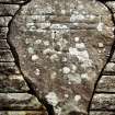
SC 382646 |
Records of the Royal Commission on the Ancient and Historical Monuments of Scotland (RCAHMS), Edinbu |
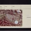
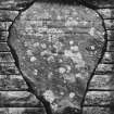
Detail of incised cross-slab built into inner face of S kirkyard dyke. |
|
Item Level |
|
 |
On-line Digital Images |
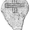
SC 382751 |
Records of the Royal Commission on the Ancient and Historical Monuments of Scotland (RCAHMS), Edinbu |
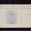
Publication drawing; Detail of Staplegordon incised cross. |
|
Item Level |
|
 |
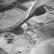
On-line Digital Images |
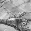
SC 1761300 |
RCAHMS Aerial Photography |
Oblique aerial view from SE, centred on Staplegordon old parish church and Barntalloch motte-and-bailey castle. Potholm farmsteading is visible in the bottom right-hand corner of the photograph. |
14/2/1996 |
Item Level |
|
 |
On-line Digital Images |
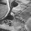
SC 1761301 |
RCAHMS Aerial Photography |
Oblique aerial view from NE, centred on Staplegordon old parish church and Barntalloch motte-and-bailey castle. Potholm farmsteading is visible in the bottom left-hand corner of the photograph. |
14/2/1996 |
Item Level |
|
 |
On-line Digital Images |
SC 1761302 |
RCAHMS Aerial Photography |
Oblique aerial view from NE, centred on Staplegordon old parish church and Barntalloch motte-and-bailey castle. Potholm farmsteading is visible in the bottom left-hand corner of the photograph. |
14/2/1996 |
Item Level |
|
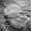 |
On-line Digital Images |
SC 1761306 |
RCAHMS Aerial Photography |
Oblique aerial view from NE, centred on a settlement and a farmsteading. Staplegordon old parish church and burial-ground is visible in the top left-hand corner of the photograph. |
14/2/1996 |
Item Level |
|
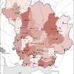 |
On-line Digital Images |
SC 1917793 |
Records of the Royal Commission on the Ancient and Historical Monuments of Scotland (RCAHMS), Edinbu |
Map showing the distribution of medieval parish churches (named) in Annandale and Eskdale, against the pattern of parish boundaries at the present day. Published in Eastern Dumfriesshire: an archaeological landscape. |
1996 |
Item Level |
|
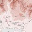 |
On-line Digital Images |
SC 1917799 |
Records of the Royal Commission on the Ancient and Historical Monuments of Scotland (RCAHMS), Edinbu |
Map showing the distribution of Anglican and medieval sculptured monuments known from Eastern Dumfriesshire. Published in Eastern Dumfriesshire: an archaeological landscape. |
1996 |
Item Level |
|
 |
On-line Digital Images |
SC 2226956 |
Papers of Betty Willsher, historian, St Andrews, Scotland |
Photographs and research notes relating to graveyard monuments in Staplegordon Churchyard, Dumfries. |
|
Item Level |
|
 |
On-line Digital Images |
SC 2226957 |
Papers of Betty Willsher, historian, St Andrews, Scotland |
Photographs and research notes relating to graveyard monuments in Staplegordon Churchyard, Dumfries. |
|
Item Level |
|
 |
On-line Digital Images |
SC 2226958 |
Papers of Betty Willsher, historian, St Andrews, Scotland |
Photographs and research notes relating to graveyard monuments in Staplegordon Churchyard, Dumfries. |
|
Item Level |
|
 |
On-line Digital Images |
SC 2226959 |
Papers of Betty Willsher, historian, St Andrews, Scotland |
Photographs and research notes relating to graveyard monuments in Staplegordon Churchyard, Dumfries. |
|
Item Level |
|
 |
On-line Digital Images |
SC 2472438 |
Records of the Ordnance Survey, Southampton, Hampshire, England |
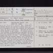
Staplegordon, Old Parish Church, NY38NE 2, Ordnance Survey index card, page number 1, Recto |
c. 1958 |
Item Level |
|
 |
On-line Digital Images |
SC 2472439 |
Records of the Ordnance Survey, Southampton, Hampshire, England |
Staplegordon, Old Parish Church, NY38NE 2, Ordnance Survey index card, page number 2, Verso |
c. 1958 |
Item Level |
|
 |
On-line Digital Images |
SC 2472440 |
Records of the Ordnance Survey, Southampton, Hampshire, England |
Staplegordon, Old Parish Church, NY38NE 2, Ordnance Survey index card, page number 1, Recto |
c. 1958 |
Item Level |
|
 |
On-line Digital Images |
SC 2472441 |
Records of the Ordnance Survey, Southampton, Hampshire, England |
Staplegordon, Old Parish Church, NY38NE 2, Ordnance Survey index card, page number 2, Verso |
c. 1958 |
Item Level |
|
 |
On-line Digital Images |
SC 2472442 |
Records of the Ordnance Survey, Southampton, Hampshire, England |
Staplegordon, Old Parish Church, NY38NE 2, Ordnance Survey index card, Recto |
c. 1958 |
Item Level |
|
 |
On-line Digital Images |
SC 2499340 |
Records of the Royal Commission on the Ancient and Historical Monuments of Scotland (RCAHMS), Edinbu |
Detail of incised cross-slab built into inner face of S kirkyard dyke. |
18/9/1995 |
Item Level |
|


