|
Photographs and Off-line Digital Images |
C 80680 CS |
Records of the Royal Commission on the Ancient and Historical Monuments of Scotland (RCAHMS), Edinbu |
Byreburnfoot, view of coal mine drain outfall into River Esk. |
10/10/1994 |
Item Level |
|
|
Prints and Drawings |
DC 32184 |
Records of the Royal Commission on the Ancient and Historical Monuments of Scotland (RCAHMS), Edinbu |
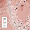
Column-width map showing the positions of industrial monuments in the vicinity of Byreburnfoot (Canonbie) and the course of the lade that supplied water to the late 18th century workings from the Tarras Water. Published in Eastern Dumfriesshire: an archaeological landscape. |
1996 |
Item Level |
|
|
Photographs and Off-line Digital Images |
D 88451 CS |
|
Outflow of drainage level at NY 3921 7815. |
1993 |
Item Level |
|
|
Photographs and Off-line Digital Images |
D 88452 CS |
|
Geological sections at Byreburnfoot and Byreburnside. |
|
Item Level |
|
|
Photographs and Off-line Digital Images |
D 88448 CS |
|
Geological map of Byreburn coal seams. |
|
Item Level |
|
|
Photographs and Off-line Digital Images |
D 88449 CS |
|
Geological section through Canonbie coalfield. |
|
Item Level |
|
|
Photographs and Off-line Digital Images |
D 88450 CS |
|
Geological map of Canonbie coalfield. |
|
Item Level |
|
|
Photographs and Off-line Digital Images |
C 92512 CS |
|
View of Park House showing possible adit indicated by staining. |
1995 |
Item Level |
|
|
Photographs and Off-line Digital Images |
C 92513 CS |
|
View of Park House showing 'old engine house'. |
1995 |
Item Level |
|
|
Digital Files (Non-image) |
GV 007473 |
Records of the Royal Commission on the Ancient and Historical Monuments of Scotland (RCAHMS), Edinbu |
Column-width map showing the positions of industrial monuments in the vicinity of Byreburnfoot (Canonbie) and the course of the lade that supplied water to the late 18th century workings from the Tarras Water. Published in Eastern Dumfriesshire: an archaeological landscape. |
1996 |
Item Level |
|
 |
On-line Digital Images |
SC 1917807 |
Records of the Royal Commission on the Ancient and Historical Monuments of Scotland (RCAHMS), Edinbu |
Column-width map showing the positions of industrial monuments in the vicinity of Byreburnfoot (Canonbie) and the course of the lade that supplied water to the late 18th century workings from the Tarras Water. Published in Eastern Dumfriesshire: an archaeological landscape. |
1996 |
Item Level |
|
 |
On-line Digital Images |
SC 2472366 |
Records of the Ordnance Survey, Southampton, Hampshire, England |
Byreburnfoot, NY37NE 34, Ordnance Survey index card, Recto |
c. 1958 |
Item Level |
|
|
Photographs and Off-line Digital Images |
SC 2697870 |
|
View of Park House showing possible adit indicated by staining. |
1995 |
Item Level |
|
|
Photographs and Off-line Digital Images |
SC 2697871 |
|
View of Park House showing 'old engine house'. |
1995 |
Item Level |
|


