
Following the launch of trove.scot in February 2025 we are now planning the retiral of some of our webservices. Canmore will be switched off on 24th June 2025. Information about the closure can be found on the HES website: Retiral of HES web services | Historic Environment Scotland
Redkirk, Old Parish Church


Burial Ground (Medieval), Church (Medieval)
Site Name Redkirk, Old Parish Church
Classification Burial Ground (Medieval), Church (Medieval)
Alternative Name(s) Red Kirk; Raynpatrick; Rinpatrick; Redkirk Point
Canmore ID 67469
Site Number NY36NW 5
NGR NY 30104 65029
Datum OSGB36 - NGR
Permalink http://canmore.org.uk/site/67469


- Council Dumfries And Galloway
- Parish Gretna
- Former Region Dumfries And Galloway
- Former District Annandale And Eskdale
- Former County Dumfries-shire
NY36NW 5 3010 6503
(NY 3010 6503) Red Kirk (NR) (site of)
OS 6" map (1957)
For Gretna, Old Parish Church and Church (NY 3192 6800), see NY36NW 31.00.
The parish church of Redkirk, also known as Raynpatrick or Rinpatrick, being dedicated to St Patrick, was probably built in the late 12th c. It was granted to the monks of Guisborough c.1170 by Robert de Brus. It was frequently in dispute between that priory and the bishops of Glasgow to whom it was ceded in 1223, but it was still connected with the priory in 1330, but thereafter became an independent parsonage under the parsonage of the bishops of Glasgow. The parish was united to Gretna in 1609, and the church fell into the sea in 1675.
A E Truckell and J Williams 1967; I B Cowan 1967; H Scott 1917
The site of Red Kirk now lies below High Water Mark and nothing survives. The published site is confirmed by Mr Truckell's own researches (curator, Dumfries Museum).
Visited by OS (RD) 19 June 1970.
Note (1981)
Redkirk, Old Parish Church and Burial-ground NY 301 650 NY36NW 5
Nothing remains of the former parish church of Redkirk or Raynpatrick which is first mentioned in about 1170. The church, which was probably superseded in 1609 when the parishes of Redkirk and Gretna were united, was destroyed by coastal erosion before 1834. See also NY36NW 31.
RCAHMS 1981
(NSA, iv, Dumfries, 266; Scott 1915-61, ii, 246; Cowan 1967, 170)
Field Visit (12 October 1993)
NY36NW 5 3010 6503
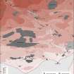
This church and its burial-ground stood at the head of Redkirk Point overlooking the Solway, but was eroded away entirely in 1675. The cliff-section has since been consolidated with granite boulders, and, although a fragment of medieval pottery was recovered from the foreshore at the date of visit, no archaeological features are now eroding from the promontory itself. There is no evidence of reused masonry in the adjacent farmstead of Redkirk (NY36NW 36).
Visited by RCAHMS (IMS), 12 October 1993.
Listed as Redkirk, church and burial-ground.
RCAHMS 1997.

