
Whinnyrig


Enclosed Settlement (Iron Age)
Site Name Whinnyrig
Classification Enclosed Settlement (Iron Age)
Canmore ID 67447
Site Number NY36NW 30
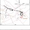
NGR NY 31283 69307
Datum OSGB36 - NGR
Permalink http://canmore.org.uk/site/67447


- Council Dumfries And Galloway
- Parish Gretna
- Former Region Dumfries And Galloway
- Former District Annandale And Eskdale
- Former County Dumfries-shire
Scheduled as 'Whinnyrig, enclosed settlement, droveway and field system 130m ENE of... on a low rise in arable farmland immediately to the west, north and east of the former steading of Whinnyrig.'
Information from Historic Scotland, scheduling document dated 19 December 2007.
Field Visit (October 1980)
Whinnyrig NY 312 693 NY36NW 30
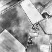
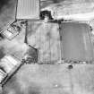
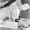
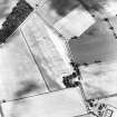
Cropmarks reveal what is probably a settlement situated beneath Whinnyrig farm steading and extending into the field to the N. Sub-rectangular on plan, it measures 80m by at least 70m within its ditch; an outer ditch has been added on the N and NE. From the entrance (on the E) two parallel ditches, 35m apart, extend for about 150m to the ENE before they are lost at the junction with another, possibly later, ditch. The northernmost of the parallel ditches continues round the N side of the settlement. See also NY36NW 26.
RCAHMS 1981, visited October 1980
Aerial Photographic Transcription (18 January 1991 - 23 January 1991)
An aerial transcription was produced from oblique aerial photographs. Information from Historic Environment Scotland (BM) 31 March 2017.
Aerial Photographic Interpretation (20 February 1996)
NY 3125 6931 NY36NW 30
Further air photography (RCAHMSAP 1984) of the settlement that is overlain by Whinnyrig steading (NY36NW 64) has provided a clearer definition of the enclosure, which probably measures about 65m from E to W by 65m transversely within its ditch. The inner ditch is broadest on the SE, where it is up to 4m in breadth, while the outer ditch is still only visible on the NE. It is conceivable that the outer ditch belongs to a separate period of occupation, and the projected circuit to the S of the entrance is hidden within the relatively broad cropmark of the inner ditch on the SE.
Information from RCAHMS (SPH), 20 February 1996.
Listed as settlement.
RCAHMS 1997.
Aerial Photographic Transcription (1 November 2012)
An interpretative transcription, or mapping, of information on oblique aerial photographs was produced on 1 November 2012.

