
Whinnyrig


Field System (Iron Age), Track (Iron Age)(Possible)
Site Name Whinnyrig
Classification Field System (Iron Age), Track (Iron Age)(Possible)
Canmore ID 67442
Site Number NY36NW 26
NGR NY 31015 69330
Datum OSGB36 - NGR
Permalink http://canmore.org.uk/site/67442


- Council Dumfries And Galloway
- Parish Gretna
- Former Region Dumfries And Galloway
- Former District Annandale And Eskdale
- Former County Dumfries-shire
Field Visit (October 1980)
Whinnyrig NY 309 693 NY36NW
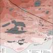
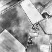
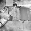
In the fields to the W of Whinnyrig settlement (NY36NW 30) cropmarks reveal the ditches of an extensive rectilinear field-system.
RCAHMS 1981, visited October 1980
Aerial Photographic Transcription (18 January 1991 - 23 January 1991)
An aerial transcription was produced from oblique aerial photographs. Information from Historic Environment Scotland (BM) 31 March 2017.
Aerial Photographic Interpretation (20 February 1996)
NY 310 693 NY36NW 26
Air photography (RCAHMSAP 1984) of the area around the settlement NY36NW 30 has shown that an area measuring at least 20ha in extent is enclosed by boundary ditches. Several junctions have been recorded, suggesting that the area has bee divided up into a series of large enclosures or fields. The most striking feature of the system is a probable droveway approaching the entrance of the settlement from the E, although one of the adjacent boundaries extends across its outer, E, end unbroken; this may simply indicate that the system was modified at some stage, and the droveway was blocked after it had fallen into disuse.
Information from RCAHMS (SPH), 20 February 1996.
Listed as ditch-system and droveway.
RCAHMS 1997.
Aerial Photographic Transcription (1 November 2012)
An interpretative transcription, or mapping, of information on oblique aerial photographs was produced on 1 November 2012.

