Pricing Change
New pricing for orders of material from this site will come into place shortly. Charges for supply of digital images, digitisation on demand, prints and licensing will be altered.
Downey Hill
Farmstead (Medieval) - (18th Century)
Site Name Downey Hill
Classification Farmstead (Medieval) - (18th Century)
Alternative Name(s) Downey Hill 2; Tanlawhill Cottages
Canmore ID 67388
Site Number NY29SW 21
NGR NY 24749 90900
Datum OSGB36 - NGR
Permalink http://canmore.org.uk/site/67388
- Council Dumfries And Galloway
- Parish Westerkirk
- Former Region Dumfries And Galloway
- Former District Annandale And Eskdale
- Former County Dumfries-shire
Remains of probable pre-improvement farmstead located within rough pasture on lower north-east facing slopes overlooking the Black Esk, within Tanlawhill ASA. Views restricted due to topography of river valley. Secluded and localised setting.
information from Héléna Gray, (CFA Archaeology Ltd), August 2015
OASIS ID: cfaarcha1-278420
NY29SW 21 24749 90900
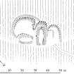
NY 2475 9091. Situated on sloping ground on the edge of a river terrace is an oval homestead. It measures 35.0m N-S by 18.5m within an earth-and- stone bank up to 2.5m thick and 0.4m high internally. The W uphill side has been levelled into to the slope to a depth of about 2.1m. Entrances probably existed on the change of slope on the N and/or S.
Within the interior there are two rectangular foundations, the more substantial in the centre apparently cutting into the remains of scooped house platform about 9.0m in diameter. The rectangular structure measures 9.5m E-W by 3.5m within a stone bank up to 2.0m and 0.5m high internally. The other rectangular structure overlies the homestead wall on the S and measures 8.5m by 3.5m internally.
The remains are typical of the small hill-slope homesteads of the area.
Enlargement at 1/1250.
Visited by OS (DWR) 25 October 1973
No change to previous field report.
Surveyed at 1:10,000.
Visited by OS (BS) 11 October 1978
Scheduled as 'Tanlawhill Cottages, farmstead 865m E of... the remains of a farmstead, visible as a series of earthworks and probably dating to the pre-Improvement period.'
Information from Historic Scotland, scheduling document dated 25 March 2010.
Homestead [NAT]
OS (GIS) MasterMap, April 2010.
Field Visit (July 1980)
Downey Hill 2 NY 247 909 NY29SW 21
Situated on a gently sloping terrace close to the foot of the NE flank of Downey Hill and 150m SE of settlement NY29SW 40 there is a roughly oval enclosure measuring 36m from NNW to SSE by 16m transversely within a stony bank up to 1.8m in thickness and 0.3m in height. The enclosure has been slightly scooped into the slope on the SW and contains the remains of at least two rectangular buildings. The larger, a platform-building, measures 10.8m from NE to SW by 3.5m transversely within massive stone wall-footings and has an entrance in its NE end; the other measures internally 8.6m from NNW to SSE by 3.5m transversely and has an entrance in its NW end. Immediately NW of the larger building there are the remains of a possible second platform-building.
RCAHMS 1980, visited July 1980
Note (1997)
NY 2475 9091 NY29SW 21
Listed as farmstead.
RCAHMS 1997.
Project (29 May 2014)
An archaeological evaluation was undertaken by CFA Archaeology Ltd, a desk based assessment and walk over survey (May 29th 2014) was conducted
The historic environment record within the Site Boundary is relatively limited, although there is some potential for the proposed development site to contain previously unknown heritage assets from at least the later prehistoric period onwards, given the historic landscape character of the wider area. Taking this into account, the archaeological potential of the proposed development site is considered to be low.
A summary assessment, on a site by site basis, of the predicted effects on the settings of assets within a 10km radius where the blade tip ZTV indicates that there would be theoretical views of one or more turbines
information from Héléna Gray, (CFA Archaeology Ltd), August 2015
OASIS ID: cfaarcha1-278420


