
Pricing Change
New pricing for orders of material from this site will come into place shortly. Charges for supply of digital images, digitisation on demand, prints and licensing will be altered.
Mill Burn


Cultivation Remains (Medieval) - (Post Medieval), Cultivation Terrace(S) (Medieval), Rig And Furrow (Medieval) - (Post Medieval)
Site Name Mill Burn
Classification Cultivation Remains (Medieval) - (Post Medieval), Cultivation Terrace(S) (Medieval), Rig And Furrow (Medieval) - (Post Medieval)
Alternative Name(s) Mill Burn 1
Canmore ID 67369
Site Number NY29SE 7
NGR NY 2547 9065
NGR Description Centred NY 2547 9065
Datum OSGB36 - NGR
Permalink http://canmore.org.uk/site/67369


- Council Dumfries And Galloway
- Parish Westerkirk
- Former Region Dumfries And Galloway
- Former District Annandale And Eskdale
- Former County Dumfries-shire
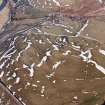
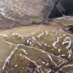
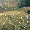
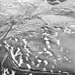
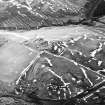
NY29SE 7 centred 2547 9065.
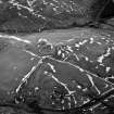
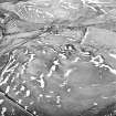
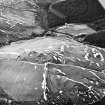
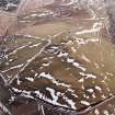
(Centred NY 2547 9065) Cultivation terraces are to be seen on RAF aerial photographs (CPE/Scot/UK 282 F20: 4092-3, flown 27 August 1947) which also show a rectangular feature.
Information from O G S Crawford, 17 March 1939.
On this hillside, there are about six cultivation terraces of varying lengths and several old field banks of minor archaeological interest.
Visited by OS (DWR) 9 October 1973
Field Visit (August 1980)
Mill Burn 1 NY 254 906 NY29SE 7
Rig cultivation on the NW flanks of Camp Hill, overlooking the Mill Burn, has created slight terracing which is partly overlain by fields of rig-and-furrow enclosed by turf banks; this later field-system is overlain by unenclosed rig-and-furrow.
RCAHMS 1980, visited August 1980

