
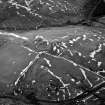
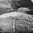
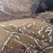
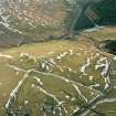
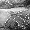
Mill Burn


Cultivation Terrace(S) (Medieval)
Site Name Mill Burn
Classification Cultivation Terrace(S) (Medieval)
Alternative Name(s) Mill Burn 2
Canmore ID 67350
Site Number NY29SE 52
NGR NY 2519 9052
NGR Description Centred at NY 2519 9052
Datum OSGB36 - NGR
Permalink http://canmore.org.uk/site/67350


- Council Dumfries And Galloway
- Parish Westerkirk
- Former Region Dumfries And Galloway
- Former District Annandale And Eskdale
- Former County Dumfries-shire
The terracing is poorly defined and extends over an area of about 2 ha.
Visited by OS 20 August 1981; area transferred from OS Record Map.
Field Visit (August 1980)
Mill Burn 2 NY 252 905 NY29SE
Slight terracing has been formed by rig cultivation on a NE-facing slope above the Mill Burn.
RCAHMS 1980, visited August 1980

