
Yards Rig


Farmstead (Medieval) - (Post Medieval), Scooped Settlement (Iron Age), Sheepfold (Post Medieval)
Site Name Yards Rig
Classification Farmstead (Medieval) - (Post Medieval), Scooped Settlement (Iron Age), Sheepfold (Post Medieval)
Alternative Name(s) Bankburnfoot
Canmore ID 67347
Site Number NY29SE 5
NGR NY 25212 92131
Datum OSGB36 - NGR
Permalink http://canmore.org.uk/site/67347


- Council Dumfries And Galloway
- Parish Eskdalemuir
- Former Region Dumfries And Galloway
- Former District Annandale And Eskdale
- Former County Dumfries-shire
NY29SE 5 2520 9213.
(NY 2520 9213) Earthwork (NR)
OS 6" map (1957)
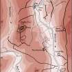
An earthen bank forming an originally oval enclosure some 170' x 130' now about 1/3 obliterated by a sheep pen. Entrance has been from the north.
RCAHMS 1920, visited 1912
The enclosure is situated on gently sloping ground on the edge of a steep slope and constitutes the remains of an oval settlement measuring 57.0m N-S by 48.0m. On the E side, the enclosure consists of an earth-and-stone bank and ditch, but elsewhere, a natural gully and steep slopes provide adequate protection. The entrance is in the N. The upper half of the interior on the E has been levelled to support timber houses. The sheep pen occupies most of the interior but has caused little destruction.
Resurveyed at 1/2500.
Visited by OS (DWR) 16 October 1973
No change to previous field report.
Surveyed at 1:10,000.
Visited by OS (BS) 17 October 1978.
NY 2539 9222. Enclosure: clear of planting.
A M Jackson 1978.
Field Visit (August 1980)
Yards Rig NY 252 921 NY29SE 5
A rectangular platform in the interior of the settlement no. 65 indicates the probable site of the farmstead of Yards. 'Johnne Batie in the Yard is' is on record in 1569, and the lands of Yards appear in a rental of the Buccleuch estate in 1646. It is likely that the farmstead was abandoned early in the 19th century.
RCAHMS 1980, visited August 1980
(SRO, GD 224/936/14; NMRS, DFD 156/1; NMRS, DFD 157/1; Hyslop and Hyslop 1912, 299; OS 6-inch map, Dumfriesshire, 1st ed., 1862, sheet xxxv)
Field Visit (1980)
Yards Rig NY 252 921 NY29SE 5
A settlement overlain by a farmstead is situated within a clearing on Yards Rig. It measures 45m by 41m internally and is enclosed on the N and E by a bank (up to 4.6m in thickness and 1.1m in height), and on the Sand W by a gully and steep slopes respectively. The entrance is on the N.
RCAHMS 1980, visited August 1980
(RCAHMS 1920, p. 76, No. 190)
Note (1997)
NY 2520 9213 NY29SE 5
Listed as settlement, overlain by farmstead.
RCAHMS 1997.

