
Raeburnfoot


Enclosure (Post Medieval), Ring Enclosure(S) (Post Medieval)
Site Name Raeburnfoot
Classification Enclosure (Post Medieval), Ring Enclosure(S) (Post Medieval)
Canmore ID 67282
Site Number NY29NE 6
NGR NY 2525 9885
Datum OSGB36 - NGR
Permalink http://canmore.org.uk/site/67282


- Council Dumfries And Galloway
- Parish Eskdalemuir
- Former Region Dumfries And Galloway
- Former District Annandale And Eskdale
- Former County Dumfries-shire
NY29NE 6 2525 9885.
(Centred NY 2525 9885) Enclosure & Hut Circles (NR)
OS 6" map (1965)
There are a number of hut circles on a slight eminence on the side of the burn opposite the Roman camp (NY29NE 5).
RCAHMS 1920, visited 1912
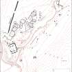
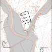
NY 2525 9885: Situated on the edge of a river terrace overlooking the confluence of the Rae Burn and White Esk to the SW are the remains of an oval enclosure measuring 32.0m N-S by 26.0m. It is formed by a single bank of earth-and-stone now reduced to a scarp in all but the E side where it is 3.5m wide and 0.2m high. A gap also in the E may have been an entrance but it is too mutilated to confirm this.
In the centre lies a circular turf-banked enclosure 10.0m in diameter and abutting the inside of the E segment is an oval enclosure measuring 10.0m by 5.0m. A short distance to the NE, there are four other circular enclosures ranging from 6.0m to 8.0m in diameter.
Although its purpose is not certain, it is apparent from its condition any type of construction, that the largest enclosure is of greater age than the others which are merely "sod dykes" of recent origin. See type site NY29NE 16.
Visited by OS (WDJ) 27 August 1962 and (IA) 12 October 1973
No change to previous field report.
Visited by OS (MJF) 1 September 1978.
Field Visit (June 1980)
Raeburnfoot NY 252 988 NY29NE 6
This enclosure is situated on a bluff 300m S of Raeburnfoot farmhouse. Roughly circular on plan, it measures about 30m in diameter within a turf bank (2.7m thick and 0.2m high) and an external ditch.
RCAHMS 1980, visited June 1980

