|
Photographs and Off-line Digital Images |
C 55521 |
RCAHMS Aerial Photography |
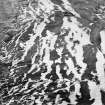
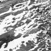
Clerk Hill, oblique aerial view, taken from the SE, centred on cord rig and cultivation remains. A number of ring-enclosures are visible in the top half of the photograph. |
14/2/1996 |
Item Level |
|
|
Photographs and Off-line Digital Images |
C 55522 |
RCAHMS Aerial Photography |
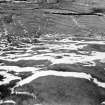
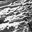
Clerk Hill, oblique aerial view, taken from the E, centred on cord rig and cultivation remains. |
14/2/1996 |
Item Level |
|
|
Photographs and Off-line Digital Images |
C 55523 |
RCAHMS Aerial Photography |
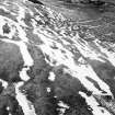
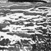
Clerk Hill, oblique aerial view, taken from the NE, centred on cord rig and cultivation remains. |
14/2/1996 |
Item Level |
|
|
Photographs and Off-line Digital Images |
C 55524 |
RCAHMS Aerial Photography |
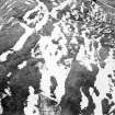
Clerk Hill, oblique aerial view, taken from the N, centred on cord rig and cultivation remains. |
14/2/1996 |
Item Level |
|
|
Photographs and Off-line Digital Images |
C 55525 |
RCAHMS Aerial Photography |
Clerk Hill, oblique aerial view, taken from the NNW, centred on cord rig and cultivation remains. |
14/2/1996 |
Item Level |
|
|
Photographs and Off-line Digital Images |
C 55526 |
RCAHMS Aerial Photography |
Clerk Hill, oblique aerial view, taken from the NW, centred on cord rig and cultivation remains. |
14/2/1996 |
Item Level |
|
|
Photographs and Off-line Digital Images |
C 55520 |
RCAHMS Aerial Photography |
Clerk Hill, oblique aerial view, taken from the SW, centred on cord rig and cultivation remains. |
14/2/1996 |
Item Level |
|
 |
On-line Digital Images |
SC 1761122 |
RCAHMS Aerial Photography |
Clerk Hill, oblique aerial view, taken from the SW, centred on cord rig and cultivation remains. |
14/2/1996 |
Item Level |
|
 |
On-line Digital Images |
SC 1761123 |
RCAHMS Aerial Photography |
Clerk Hill, oblique aerial view, taken from the SE, centred on cord rig and cultivation remains. A number of ring-enclosures are visible in the top half of the photograph. |
14/2/1996 |
Item Level |
|
 |
On-line Digital Images |
SC 1761124 |
RCAHMS Aerial Photography |
Clerk Hill, oblique aerial view, taken from the E, centred on cord rig and cultivation remains. |
14/2/1996 |
Item Level |
|
 |
On-line Digital Images |
SC 1761125 |
RCAHMS Aerial Photography |
Clerk Hill, oblique aerial view, taken from the NE, centred on cord rig and cultivation remains. |
14/2/1996 |
Item Level |
|
 |
On-line Digital Images |
SC 1761126 |
RCAHMS Aerial Photography |
Clerk Hill, oblique aerial view, taken from the N, centred on cord rig and cultivation remains. |
14/2/1996 |
Item Level |
|
 |
On-line Digital Images |
SC 1761127 |
RCAHMS Aerial Photography |
Clerk Hill, oblique aerial view, taken from the NNW, centred on cord rig and cultivation remains. |
14/2/1996 |
Item Level |
|
 |
On-line Digital Images |
SC 1761128 |
RCAHMS Aerial Photography |
Clerk Hill, oblique aerial view, taken from the NW, centred on cord rig and cultivation remains. |
14/2/1996 |
Item Level |
|
 |
On-line Digital Images |
SC 2471868 |
Records of the Ordnance Survey, Southampton, Hampshire, England |
Clerk Hill, NY29NE 55, Ordnance Survey index card, Recto |
c. 1958 |
Item Level |
|


