
Raeburnfoot


Enclosure(S) (Period Unassigned), Ring Enclosure(S) (Period Unassigned)
Site Name Raeburnfoot
Classification Enclosure(S) (Period Unassigned), Ring Enclosure(S) (Period Unassigned)
Canmore ID 67230
Site Number NY29NE 1
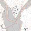
NGR NY 256 996
NGR Description Centred NY 256 996
Datum OSGB36 - NGR
Permalink http://canmore.org.uk/site/67230


- Council Dumfries And Galloway
- Parish Eskdalemuir
- Former Region Dumfries And Galloway
- Former District Annandale And Eskdale
- Former County Dumfries-shire
NY29NE 1 256 996.
(Centred NY 2564 9963) Hut Circles (NR)
OS 6" map (1965)
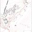
Two turf-covered enclosures side by side, well defined and both equally obvious. Diameter of N one 5 yds. Diameter of S one 12 yds. (A small rectangle, rather rounded, ditch marked on W side; interior raised). No gaps for entrances to be seen in either.
Information from O G S Crawford 16 March 1939
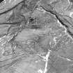
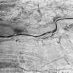
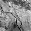
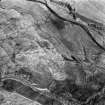
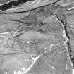
NY 2561 9965. Situated obove the flood plain is a group of seven circular, turf-banked enclosures (A) varying from 5.0 to 8.0m in diameter and one oval enclosure (B) at NY 2560 9961, measuring 12.0 by 10.0m. They are all 'sod dykes' for use as sheep pens. See type site NY29NE 16.
Visited by OS (WDJ) 21 August 1962 and (IA) 9 October 1973
Photographed by the RCAHMS in 1980, who list these features as 'Enclosures and Ring-enclosures'. However, they do not appear in the list of sites and monuments in Upper Eskdale, and are therefore not considered to be antiquities.
RCAHMS 1980; (undated) information in OS archaeology record cards.

