
Cocklaw


Cairn(S) (Bronze Age), Cist (Bronze Age), Cremation (Bronze Age)
Site Name Cocklaw
Classification Cairn(S) (Bronze Age), Cist (Bronze Age), Cremation (Bronze Age)
Alternative Name(s) Callisterhall; Westwater
Canmore ID 67188
Site Number NY28SE 12
NGR NY 2984 8228
NGR Description NY 2984 8228 and NY 2985 8235
Datum OSGB36 - NGR
Permalink http://canmore.org.uk/site/67188


- Council Dumfries And Galloway
- Parish Langholm
- Former Region Dumfries And Galloway
- Former District Annandale And Eskdale
- Former County Dumfries-shire
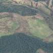
Remains of Bronze age burial cairn located on spur of Cock Law on east facing slopes within rough pasture but adjacent to several areas of forestry planting / ploughed forestry land. Distant views in north, east and south arc; slightly more restricted views to north.
information from Héléna Gray, (CFA Archaeology Ltd), August 2015
OASIS ID: cfaarcha1-278420
NY28SE 12 2984 8228.
Three cairns have been found on the hill W of Westwater farm (NY38SW 20). The principal one contained a cist, lying NE-SW and measuring 3ft 2ins by 1ft 6ins and 1ft 3ins in depth. Though it was very carefully examined by Mr J M Elliot of Westwater, only a few fragments of calcined bone were found.
The remains of the other two cairns lie about 100 yards to the N, and a little lower on the hill.
J and R Hyslop 1912
NY 2984 8228. A mutilated turf-covered cairn lies at 248m OD just off the summit area of a sloping ridge. It is 8.0m in diameter and 0.6m high and is cut by a 1.8m wide, 0.7m deep trench. The cist is not evident but there are a number of large boulders protruding from the trench and these may be part of the cist remains.
NY 2985 8235. An oval spread of large stones, situated lower down the hillslope, is 4.0m by 3.0m and 0.2m high. The centre has been disturbed but nothing of significance has been exposed. This feature appears to be a stone cleareance spread rather than a cairn.
NY 2985 8239. A disturbed mound of large stones, which has been fashioned into a crude windbreak, is approximately 5.6m by 4.9m and up to 0.9m high. It cannot be identified as a cairn from the present ground evidence.
Cairn surveyed at 1/10,000.
Visited by OS (MJF) 1 September 1979
The cairns noted by Hyslop and Hyslop cannot be located, and may be obscured by any of the numerous recent field clearance heaps in the area.
M J Yates 1984.
Field Visit (March 1981)
Cocklaw, Westwater 1 NY 298 822 NY28SE 12
A slab-built cist (aligned NE-SW and in which 'a few fragments of calcined bone' were found) was noted in the centre of the cairn at NY 2984 8228, when seen in 1981.
Cocklaw, Westwater 2 NY 298 823 NY28SE 12
The feature at NY 2985 8235 (110m further N) is described as a possible robbed cairn, measuring about 8m in diameter and up to 0.4m in height, and partly covered by a heap of large boulders.
(No mention is made of the feature at NY 2985 8239; it has therefore been dismissed as not an antiquity).
RCAHMS 1981, visited March 1981;
(J and R Hyslop 1912, (undated) information from OS Archaeology Branch recorder)
Note (1997)
NY28SE 12 2984 8228 and 2985 8229
Listed as cairns.
RCAHMS 1997.
Project (29 May 2014)
An archaeological evaluation was undertaken by CFA Archaeology Ltd, a desk based assessment and walk over survey (May 29th 2014) was conducted
The historic environment record within the Site Boundary is relatively limited, although there is some potential for the proposed development site to contain previously unknown heritage assets from at least the later prehistoric period onwards, given the historic landscape character of the wider area. Taking this into account, the archaeological potential of the proposed development site is considered to be low.
A summary assessment, on a site by site basis, of the predicted effects on the settings of assets within a 10km radius where the blade tip ZTV indicates that there would be theoretical views of one or more turbines
information from Héléna Gray, (CFA Archaeology Ltd), August 2015
OASIS ID: cfaarcha1-278420

