
Torwood


Temporary Camp (Roman)
Site Name Torwood
Classification Temporary Camp (Roman)
Alternative Name(s) Lochside
Canmore ID 66815
Site Number NY18SW 11
NGR NY 12191 81989
Datum OSGB36 - NGR
Permalink http://canmore.org.uk/site/66815


- Council Dumfries And Galloway
- Parish Dryfesdale
- Former Region Dumfries And Galloway
- Former District Annandale And Eskdale
- Former County Dumfries-shire
NY18SW 11.00 12191 81989
NY18SW 11.01 1212 8192 Torwood Enclosure
(Centred NY 8198) Roman Camp (R) (Site of)
OS 6" map (1957)
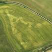
This Roman marching camp, the ditch now confused by field boundaries, measures about 1,500' by (if Roy's conjectural position of the E side can be accepted) 1,000'. The rampart is best preserved in the small triangular extension to the S of Duke's Wood, and at the NW angle, where the mound is 14' wide. at 212 and 347 paces S of this angle lie the two tutuli, 36' long, planned by Roy. The course of the rampart on the W side is marked by the hedge along the fields and the greater part of the N side, with a central gate, where there seems to have been a very slight change in direction, has been seen as crop marks.
APs show further markings in the area.
J Macdonald 1894; J K St Joseph 1952; 1965
This marching camp is generally as described above, except that the tituli are no longer visible, having probably been destroyed by reafforestation. There is no trace on the ground of the feature shown as a crop mark on St Joseph air photograph at NY 1212 8192.
Surveyed at 1/2500.
Visited by OS (EGC) 17 June 1966.
Note (1997)
NY 1220 8198 NY18SW 11
Listed as temporary camp.
RCAHMS 1997.
Publication Account (17 December 2011)
The camp at Torwood, Lochside, lies on gently sloping ground east of the Dryfe Water close to its confluence with the River Annan; the Roman fort of Ladyward is sited some 600m to the west. First recorded in 1769 by Roy (1793: Pl. VII), a small part of the camp survives as an upstanding earthwork, with most of the remainder revealed through cropmarkings on aerial photographs. The camp measures about 452m from north-east to south-west, although it has a pronounced corner extension to its western angle; its transverse dimension is 330m, and the camp enclosed 15.3ha (almost 38 acres). Entrance gaps protected by tituli are visible in the north-east and southwest sides; two tituli were recorded on the north-west side in Dukes Wood in 1956 (RCAHMS St Joseph Collection: Notebook 1). These were recorded as measuring up to 11m long, 3.3m wide with a ditch 1.8m wide (RCAHMS St Joseph Collection: Notebook 1) but are no longer visible today.
R H Jones.

