
Hutton Mote


Motte (Medieval)
Site Name Hutton Mote
Classification Motte (Medieval)
Alternative Name(s) Hutton Motte; Hutton, Motte-and-bailey
Canmore ID 66755
Site Number NY18NE 1
NGR NY 16352 89362
Datum OSGB36 - NGR
Permalink http://canmore.org.uk/site/66755


- Council Dumfries And Galloway
- Parish Hutton And Corrie
- Former Region Dumfries And Galloway
- Former District Annandale And Eskdale
- Former County Dumfries-shire
NY18NE 1 16352 89362
(NY 1635 8936) Hutton Mote (NR)
OS 6" map (1957)
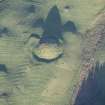
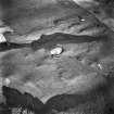
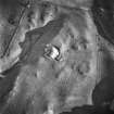
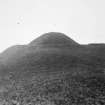
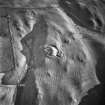
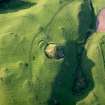
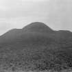
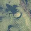
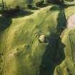
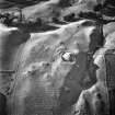
A truncated cone 23' high above a rocky knoll on which it is constructed, and surrounded at its base by a ditch varying in width from 28 -10' and 7 - 3' in depth. In a grant dated 1664, of part of the lands of Hutton, there is mention of the 'Mote'.
Formerly used as a beacon and signal post.
Name Book 1858; RCAHMS 1920; T L Taylor 1934.
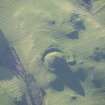
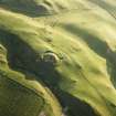
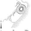
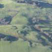
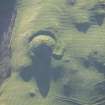
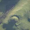
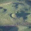
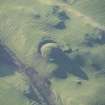
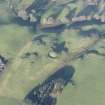
Situated on the end of a low ridge, this motte measures 31m in diameter and is surrounded by a ditch. Soil slip and sheep-scrapes have slightly reduced the mound and covered the ditch in the E. In the NE the ditch has been extended to partially enclose a sub-rectangular platform c. 7.0m wide by c. 14.0m long. Name confirmed.
Resurveyed at 1:2500.
Visited by OS (DWR) 20 December 1971.
Scheduled as 'Hutton Mote... the upstanding remains of as motte and possibly bailey...'
Information from Historic Scotland, scheduling document dated 15 March 2010.
Hutton Mote [NAT]
OS (GIS) MasterMap, April 2010.
Measured Survey (31 March 1994)
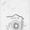
RCAHMS surveyed the motte at Hutton Mote on 31 March 1994 with plane-table and self-reducing alidade at a scale of 1:500. The plan was redrawn in ink and published at a scale of 1:2500 (RCAHMS 1997, Fig. 202).
Field Visit (31 March 1994)
NY 1635 8936 NY18NE 1
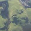
This motte is situated in a commanding position at the NE end of a flat-topped ridge. Some 30m in diameter at the base, it stands to a height of 7m within a ditch 7m broad and up to 2m deep. It suffers heavily from erosion by rabbits, sheep and cattle, which has revealed naturally outcropping rock in its lower levels, and its once-flat top appears to have been largely removed.
At the base of the motte on the NW, an L-shaped extension of the ditch, with an internal bank, flanks two sides of a rectangular platform measuring 10m by 5m.
To the SW, the summit of the ridge provides a natural bailey and, 40m from the base of the motte, a slight depression traversing the ridge may indicate the presence of a bailey ditch.
Visited by RCAHMS (PC), 31 March 1994.
Listed as motte-and-bailey.
RCAHMS 1997.

